As a result of a contact to one of us by the Washington Post reporter Evan Hill on October 4, 2024, we learned that the Israelis reportedly bombed the Al Qusayr Underground Facility in Syria (close to the Lebanon border) and another nearby site in Lebanon. For years, the Institute has been following and reporting on this site, where construction started as early as 2009 and continued until recently. We decided to seek and analyze post-attack imagery.
Hill also provided X.com reporting on these strikes. Emanual Fabian, a Times of Israel military correspondent, reported early morning October 4, 2024, that "Israeli fighter jets struck a 3.5 kilometer-long tunnel that crossed between Lebanon and Syria, which the IDF says was used by Hezbollah to smuggle Iranian weapons." [1] He stated that Hezbollah Unit 4400, tasked with delivering weapons from Iran to its proxies in Lebanon, used the tunnel. Fabian added that a "separate overnight strike targeted "infrastructure" at the Masnaa Border Crossing, between Lebanon and Syria, after the IDF said it identified attempts to deliver Iranian weapons to Hezbollah."
An anonymous person, Samir, @obretix, soon afterwards highlighted on X.com that the distance between the Al Qusayr site and the building destroyed near the Masnaa Border Crossing is slightly over three kilometers. [2]
The recent destruction described in Fabian's reporting can be seen in commercial satellite imagery on October 5, 2024. Imagery showed that the sites were intact during the daytime of October 3rd. Based on a Google Earth derived elevation profile, a tunnel from Al Qusayr to the building in Lebanon is feasible.
Background on Institute Work on Al Qusayr
The Institute's focus on Al Qusayr resulted from a decision to follow up a 2015 Der Spiegel report stating a nuclear connection with the Syrian Al Kibar reactor destroyed by Israel in 2007. Prior to its destruction, the Al Kibar reactor was an unfinished plutonium production reactor at Al Kibar that was being built with North Korean assistance. An unanswered question after the 2007 bombing was the location and fate of the many tonnes of uranium fuel that North Korea had shipped to Syria for this reactor. Our investigations could not confirm any link between Al Qusayr and the Al Kibar reactor project, however the site appeared to serve an important military purpose and long-term ongoing internal excavation was evident from satellite imagery. Our more recent analysis, including extensive commercial imagery of the site, are below:
"Continued Activity Identified at Al Qusayr, Syria," by David Albright, Sarah Burkhard, Spencer Faragasso, April 12, 2023, https://isis-online.org/isis-reports/detail/continued-activity-identified-at-al-qusayr-syria/
"Is the facility at Qusayr, Syria an underground nuclear facility? Public Evidence remains inconclusive," by David Albright, Sarah Burkhard, Allison Lach, and Frank Pabian, March 21, 2018, https://isis-online.org/isis-reports/detail/is-the-facility-at-qusayr-syria-an-underground-nuclear-facility/14
Attack Assessment
Using a MAXAR October 5, 2024, image, the Institute's bomb damage assessment finds that there were likely multiple strikes on each of three main buildings at Al Qusayr that had provided underground access (Figures 1 and 2). Two other bomb craters can be seen in the vicinity. One crater was centered on the Security Checkpoint at the entrance to the Al Qusayr facility (which could have damaged some service utility structures (water and power) that were known to have served the site. The second crater, measuring eight meters in diameter, was near the entrance road between the checkpoint and the underground entrance area. The likely ventilation structure uphill from the facility, identified in earlier Institute studies, had not been hit.
The Institute obtained commercial satellite imagery of the second site in Lebanon situated 3.1 kilometers from the Al Qusayr Underground Facility showing that it was also completely destroyed between October 3, 2024, and October 5, 2024. (We are naming this building as the Mrah El Zakbeh site, given that this is the name of the closest hamlet). The Mrah El Zakbeh site consisted of a single large drive-in revetted building set into a cut-out hillside where a tunnel could be accessed (See Figures 3, 4, and 5). It also had a small solar panel array on the roof as seen in Figure 4. Note that on the shadowed northwest side there appears to have been a large ventilation type grid set into the hillside. So, it was not merely a retaining wall, there is/was likely something inside the hill. Figure 5, Google Earth images from February 9, 2021 (top) and June 17, 2023 (bottom) show that the building was butted up to the hillside, and had a large drive through door on its southeast side.
A Google Earth derived elevation profile between the two destroyed sites shows that it is indeed possible that the two sites could have been connected via a tunnel. See Figure 6.
Last Word
The Israeli statement is credible that these two long-standing sites were part of a transportation system to move arms from Iran to proxies in Lebanon. It is still worth knowing, or at least eliminating the possibility that the Al Qusayr site had other purposes as well such as storage for a host of illicit materials that could have included nuclear or missile related materiel.
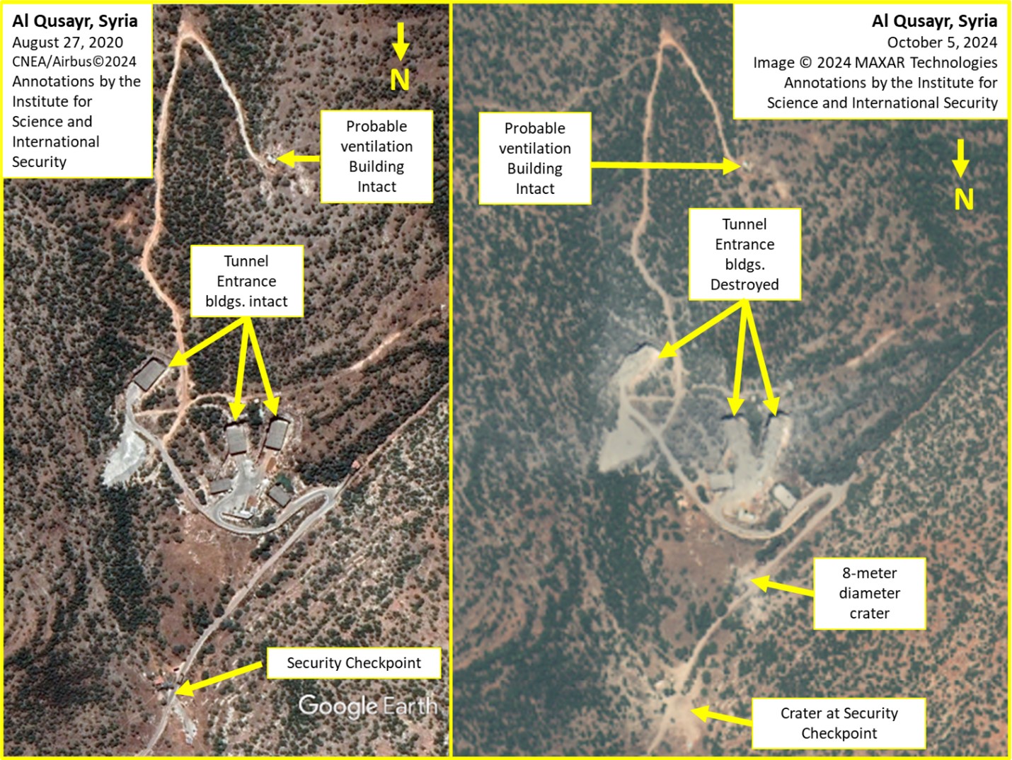
Figure 1. Before and after images showing the strike on the Al Qusayr site.
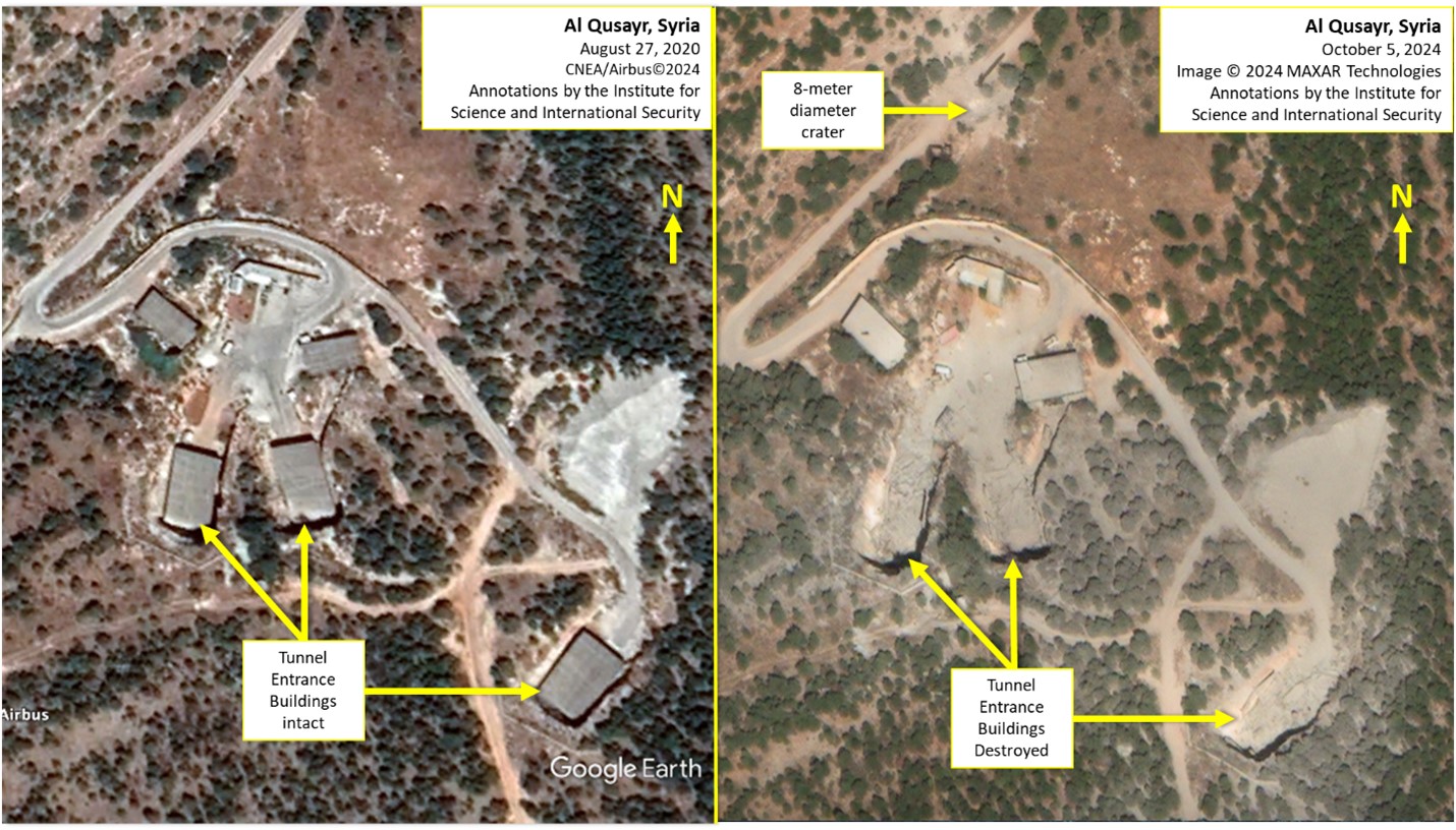
Figure 2. A closeup comparison of the Al Qusayr site before and after the attack on the night of October 3rd and 4th.
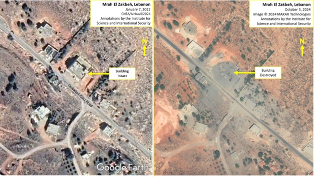
Figure 3. A comparison of the site, called Mrah El Zakbeh site, before and after the attack on the night of October 3rd and 4th.
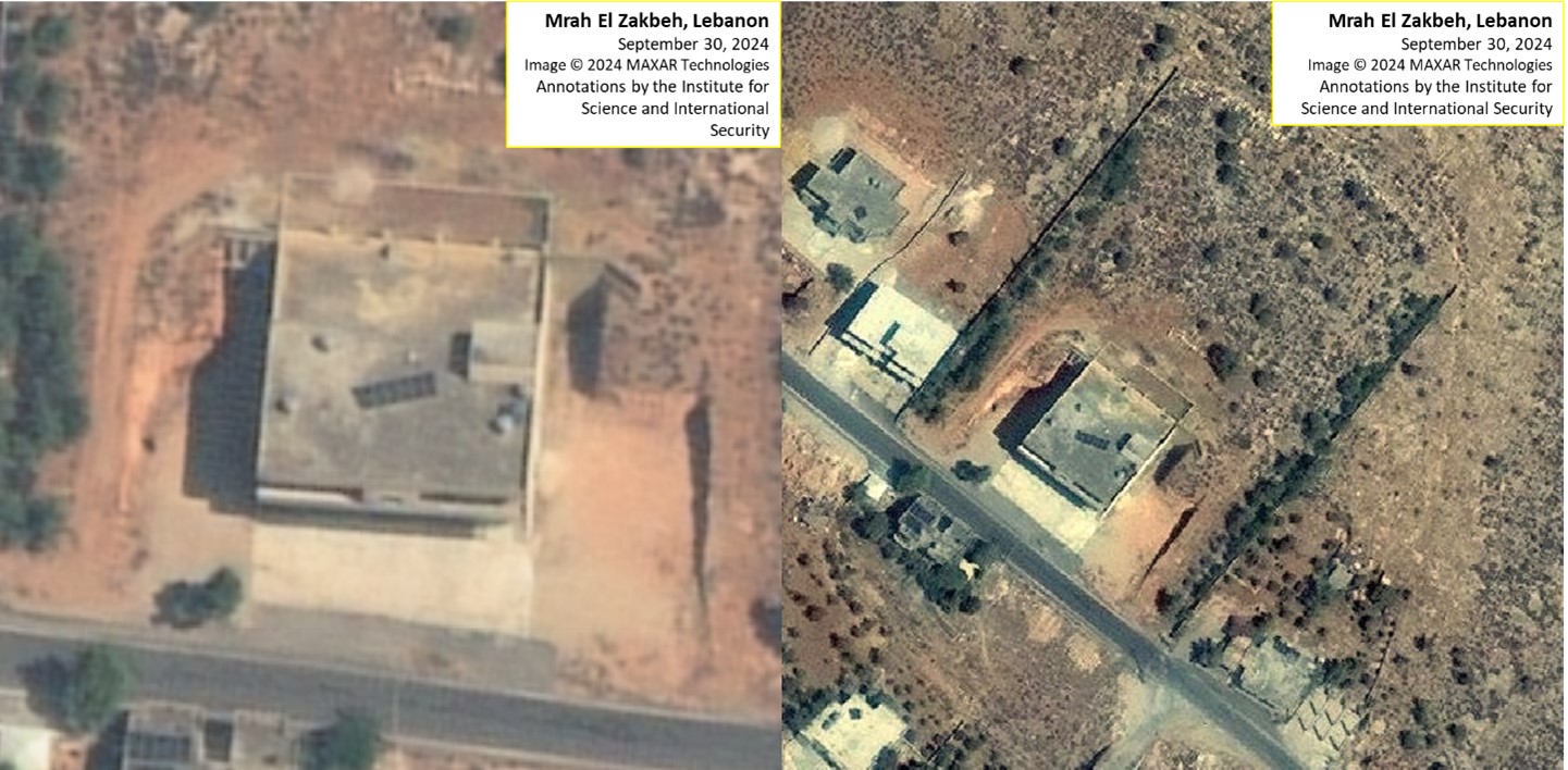
Figure 4. Two tiles from a September 30th MAXAR image of the Mrah El Zakbeh showing a closeup of the building and its surroundings with a perimeter visible extending back into the hillside.
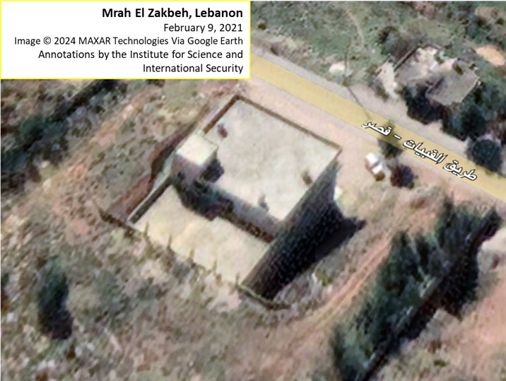
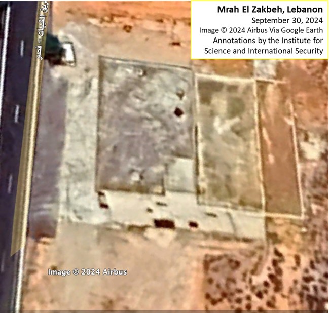
Figure 5. Two views from Google Earth images, dated February 9, 2021 (top) and June 17, 2023 (bottom), of the Mrah El Zakbeh site. The upper image shows the northwest side of the building, which is butted up to the hillside. The lower image provides another view of the building, showing the southeast side had a large vehicle accessible door.
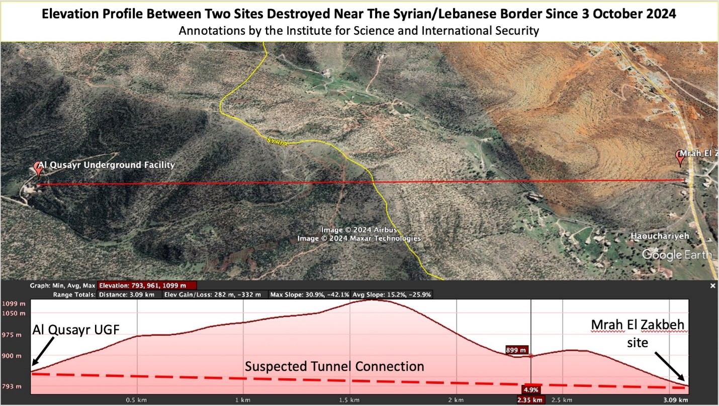
Figure 6. The two sites can be connected by a tunnel about 3.1 kilometers in length running generally from north (left) to south (right) under the Syrian/Lebanese border (yellow line).
1. Emanuel (Mannie) Fabian, X, @manniefabian, October 4, 2023, 6:36 am, https://x.com/manniefabian/status/1842151774674903526. [↩]
2. https://x.com/obretix/status/1842267448818765914. [↩]


