A new study has given key insights into South Australia's coastal management by examining how Cape Dombey's rocky headland in Robe on the state's Limestone Coast influences waves, currents and sand movement.

By collecting real-world data over summer and winter, the Flinders University researchers have identified key patterns in how sand moves past the headland, in a process known as 'headland bypassing'.
The study's findings provide a detailed framework for understanding how headlands influence sand movement, providing explanations for why Robe's popular tourist beaches are either building or eroding at various times.
By refining how we measure and analyse headland bypassing, this research paves the way for better coastal management strategies, ensuring beaches remain stable and resilient in the face of changing wave and weather conditions.
These coastal features, while specific to Robe, are also seen in other global locations, says study author Charlotte Uphues, from the Beach and Dune Systems (BEADS) Lab at Flinders University.
"This research provides a deeper understanding of the forces at play along the coastline of Robe," says Ms Uphues, whose research is supported by an Enterprise Industry PhD Scholarship jointly funded by the District Council of Robe and Flinders University.

"By studying how Cape Dombey's headland shapes the movement of sand, we can better predict changes to the local beaches and develop more effective management strategies."
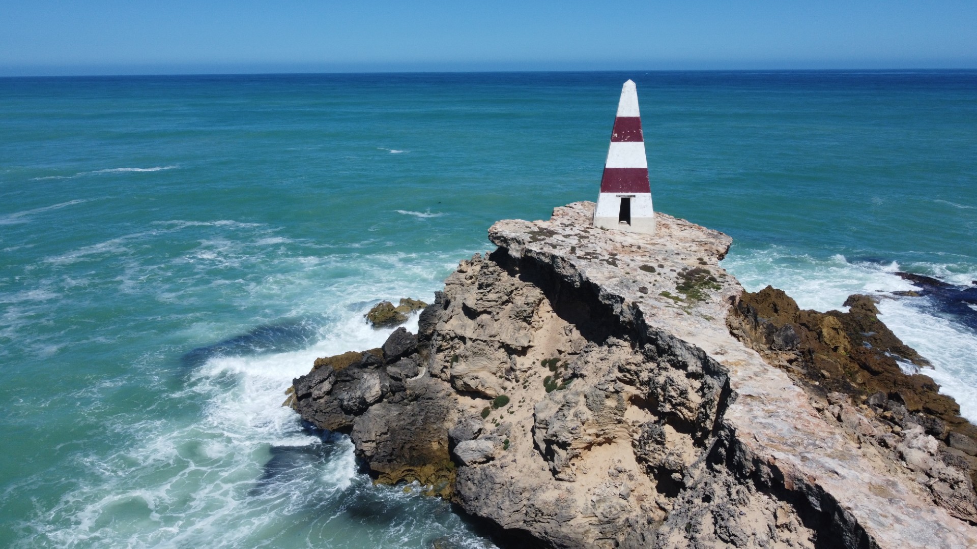
Local government and the public are actively working on future management strategies, including discussions about the possible replication of the historic obelisk on Cape Dombey due to extensive erosion in recent years.

leafy seadragon in SA waters. Photo by Carina Kraft.
The research is now underpinning the council's draft Coastal Adaptation Strategy, which is set to be adopted at the Council's meeting this month (12 February 2025). The strategy aims to protect Robe's coastline and adapt to the challenges of climate change and coastal erosion.
The Robe obelisk, erected in 1855 as a 'day guide' for ships entering Guichen Bay, stands on the headland but faces eventual collapse due to the erosion of the soft sandstone cliffs.
District Council of Robe Mayor Lisa Ruffell says the Flinders University research will play an important role in shaping the coastal challenges.
"The findings from this study provide valuable insights into the dynamic processes that shape our coastline," says Mayor Ruffell. "Understanding how the Cape Dombey headland affects the movement of sand is crucial as we work on our Coastal Adaptation Strategy. This will help us better manage our beaches, protect the natural beauty of Robe, and ensure a resilient coastal environment for the future."
As well as the prominent Cape Dombey headland, the area contains smaller headlands and sheltered beaches on its lee side. The complex coastal environment, with its varying wave climate and submerged reefs, further shapes sand movement in the area.
The study, outlined in a new article in Marine Geology, found that the shape of the headland and underwater features significantly impact how waves behave as they move from offshore to inshore.
When waves bend around the headland or break over submerged reefs, they lose energy, particularly when coming from the south or southwest during low water levels. This loss of energy changes how much sediment is transported towards beaches on the sheltered/downdrift site of the headland.
The research identifies three distinct ways in which sand is transported around Cape Dombey:
SLOW movement in mild conditions - When waves are small and water levels are low, currents flow around the headland, leading to minimal sand movement. This slow process can help build up sand on the sheltered side of the headland.
STRONG transport across the bay - When waves grow larger and water levels rise, currents start moving sand across the bay at rates up to 30 times higher than in the mild conditions.
POWERFUL offshore transport - During storms, especially when waves come from the northwest, strong currents can pull sand away from the coast at rates up to 40 times higher than under mild conditions. These storm surges can significantly reduce sand on beaches.
The article, 'Sediment bypassing around a headland in a high-energy coastal environment' (2025) by Charlotte FK Uphues, Graziela Miot da Silva, Arnold van Rooijen (University of Western Australia) and Patrick A Hesp has been published in the journal Marine Geology. DOI: 10.1016/j.margeo.2025.107491.
Acknowledgements: The authors gratefully acknowledge the assistance of Robe District Council and Flinders University. A.Rooijen was supported by a Forrest Prospect Fellowship from the Forrest Research Foundation. Thanks also to Paul Regnier (Robe Professional Fishermen's Association), SARDI, DEW, the BEADS Lab and Freya Barr, Carina Kraft, Lea Krätzig, Nienke van Popta, Juul Smets, and Adrien Flament for their field assistance.


