
8 min read
Welcome to a new era for The Earth Observer newsletter! This communication marks the official public release of our new website. While this release moves us into a new online future, the newsletter team has worked to ensure the new website also allows for continuity with our publication's robust 35-year history. The Executive Editor has written a more detailed overview of our new site that is posted separately.
I am happy to report on the success of several recent launches. The Geostationary Operational Environmental Satellite-U (GOES-U) successfully launched at 5:26 PM Eastern Daylight Time (EDT) on June 25 aboard a SpaceX Falcon Heavy rocket from Launch Complex 39A at NASA's Kennedy Space Center in Florida.
GOES-U (renamed GOES-19 after reaching geostationary orbit on July 8) is the fourth and final satellite in the GOES-R Series, providing advanced imagery and atmospheric measurements, real-time mapping of lightning activity, and space weather observations. Once the checkout phase is complete, NASA will hand operational control to NOAA. After checkout, the plan is for GOES-19 to replace GOES-16 (originally GOES-R) as GOES-East. GOES-19 will work in tandem with GOES-18 (GOES-T), NOAA's GOES-West satellite, to enable observations from the west coast of Africa to New Zealand.
In addition to its critical role in terrestrial weather prediction, the GOES constellation of satellites helps forecasters predict near Earth space weather that can interfere with satellite and terrestrial electronics and communication. The GOES-U satellite goes beyond the capabilities of its predecessors with a new space weather instrument, the Compact Coronagraph-1 (CCOR-1), which blocks light from the solar disk to allow imagery of the faint solar corona, providing low latency observations for detecting coronal mass ejections.
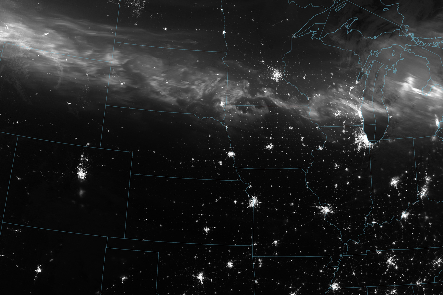
Speaking of space weather, Solar Cycle 25 is nearing its peak, which typically results in an increase in solar activity and geomagnetic storms. A particularly intense geomagnetic storm took place in mid-May 2024-the strongest in over two decades The G5 storm culminated in a remarkable display of the aurora overnight-in both hemispheres-on May 10-11, visible from many areas worldwide-including latitudes where sightings of auroras are uncommon. It also caused concerns for the safety of some of NASA's Earth science satellite missions, although fortunately there was no lasting impact.
The aurora produced by the storm could be observed from the day-night band on the NASA-NOAA Suomi NPP Visible Infrared Imaging Radiometer Suite (VIIRS) that is sensitive enough to detect nighttime light across a broad band of wavelengths (green to near-infrared) to observe signals such as city lights, reflected moonlight, and auroras. VIIRS captured the image shown below on the night of May 11, 2024.
There were two deployments from the International Space Station (ISS) as part of NASA's Earth Science Technology Office (ESTO) In-Space Validation of Earth Science Technologies (InVEST) program. The SigNals Of Opportunity: P-band Investigation (SNOOPI) was launched on March 21 from NASA's Cape Canaveral Space Force Station to the International Space Station aboard SpaceX's Dragon cargo spacecraft (CRS-30) as part of the company's thirtieth commercial resupply mission. On April 21, the instrument was released into orbit from the station. The SNOOPI mission will demonstrate and validate the in-space use of P-band (~300 MHz) signals of opportunity to measure root zone soil moisture and snow water equivalent, reducing the risk of utilizing this technique on future space missions. SNOOPI will also verify important assumptions about reflected signal coherence, robustness to the RFI environment, and the ability to capture and process the transmitted signal in space. James Garrison [Purdue University] is PI for SNOOPI, with co-investigators from GSFC.
The Hyperspectral Thermal Imager (HyTI) CubeSat was also flown aboard CRS-30 and deployed from the ISS. HyTI is a technology demonstration mission by the University of Hawaiiʻi at Mānoa designed to demonstrate how high spatial resolution (60-m ground resolution), high spectral resolution (25 bands), and long-wave infrared image data can be acquired to monitor water resources using a 6U CubeSat. Robert Wright [University of Hawaiʻi at Mānoa] is principal investigator for HyTI.
NASA is conducting the Arctic Radiation Cloud Aerosol Surface Interaction Experiment (ARCSIX) over the Arctic Ocean north of Greenland this spring and summer. Altogether, about 75 scientists (including sea ice surface researchers, aerosol researchers, and cloud researchers), along with instrument operators and flight crew, are participating in ARCSIX's two phases based out of Pituffik Space Base in northwest Greenland. The first three-week deployment, from late May to mid-June of this year, was timed to document the start of the ice melt season. The second deployment will occur in late July and August to monitor late summer conditions leading up to the freeze-up period.
As part of ARCSIX, NASA is flying two of its aircraft, with the first flights having occurred on May 28, 2024. The P-3 Orion aircraft from NASA's Wallops Flight Facility flies at relatively low altitudes to characterize sea ice surface properties, the optical and microphysical properties of cloud and aerosol particles, atmospheric chemistry, radiative fluxes, and other lower atmospheric properties. At the same time, a Gulfstream III aircraft, managed by NASA's Langley Research Center, flies at higher altitudes to provide hyperspectral imagery and obtain atmospheric profiles, adding a perspective similar to those of orbiting satellites.
Two members of NASA's Earth observing fleet celebrate milestone anniversaries this summer. The third of NASA's EOS Flagships-Aura-marks 20 years in orbit on July 15. During the 1990s and early 2000s, an international team of engineers and scientists worked together to design the first integrated observatory for studying atmospheric composition. This was a "bold endeavor" at the time, intended to provide unprecedented detail essential to understanding how Earth's ozone layer and air quality respond to changes in atmospheric composition caused by both human activities and natural phenomena, a key NASA Earth science objective. The Aura spacecraft (Latin for "breeze" and "air") was launched on July 15, 2004, with its four instruments.
Twenty years later, the spacecraft and two of its instruments, the Microwave Limb Sounder (MLS) and Ozone Monitoring Instrument (OMI), are in remarkable shape, which is a testament to Aura's solid engineering. MLS and OMI are remarkably stable, allowing for the continuation of their science- and trend-quality datasets. However, all good things must come to an end. Insufficient solar power generation will require that data collection end in mid-2026. In the meantime, MLS and OMI will continue to monitor the everchanging composition of Earth's atmosphere. I extend my congratulations to Bryan Duncan [GSFC-Aura Project Scientist] and the entire Aura team, past and present, on this remarkable achievement.
On July 2, 2024, the Orbiting Carbon Observatory-2 (OCO-2) celebrated ten years since its launch, marking a decade of gold-standard measurements of carbon dioxide (CO2) from space. OCO-2 was originally designed as a pathfinder mission to measure CO2 with the precision and accuracy needed to quantify regional sources and sinks of this key greenhouse gas.
OCO-2 has tracked the relentless rise of CO2 in our atmosphere and has provided unprecedented information on where, when, and how CO2 is released into and removed from the atmosphere. OCO-2 data have provided new insights into how CO2 emissions are offset by natural carbon sinks such as forests and oceans. The data have demonstrated that spaceborne measurements can be used to accurately quantify CO2 emissions from power plants and cities. The long-term, global record has also been used to examine the two-way interactions between CO2 and climate. As the length of the data record has increased, OCO-2 is beginning to be able to provide policy-relevant information and to address an ever more diverse range of carbon cycle science questions. Because of the mission's success, NASA now has two instruments in space monitoring Earth's carbon cycle. OCO-2's spare parts were repurposed and nested as OCO-3 on the International Space Station in 2019. OCO-2 is unique among NASA missions in providing near-global sampling in combination with the spectral resolution and signal to noise needed to provide CO2 with the sensitivity required to inform studies of the natural carbon cycle as well as anthropogenic sources. The OCO-2 mission has been and will remain a key element of any U.S. or international greenhouse gas observational network to enhance our scientific understanding of the carbon cycle and inform climate mitigation efforts. Congratulations to Vivienne Payne [JPL-OCO-2 Principal Investigator] and the entire OCO-2 team on this noteworthy achievement.
The Earth Observer plans more in-depth feature coverage of both these missions celebrating milestones in July over the coming months. Last but certainly not least, I would like to congratulate Sarah Ringerud [GSFC] on being chosen as the Deputy Project Scientist for the Global Precipitation Measurement (GPM) mission. Ringerud holds a Ph.D. in Atmospheric Science with an emphasis on Remote Sensing from Colorado State University. Ringerud is a research meteorologist at GSFC, leading projects focused on GPM and future mission concepts. Her expertise lies in satellite algorithm development, particularly for microwave instruments, and she actively collaborates with government and academic partners to advance the field of precipitation remote sensing. Congratulations to Sarah and best wishes in her new role.
Steve Platnick
EOS Senior Project Scientist


