As the world focuses on glacier preservation this UN World Water Day, researchers at the University of Waterloo are exploring the glaciers of the Yukon's St. Elias Mountains. These massive bodies of ice, part of the planet's highest coastal mountain range, are more than just stunning landscapes-they are a vital source of Canada's frozen water and key to understanding sea level rise and future water security.
The St. Elias Mountains hold approximately 32,100 square kilometers of glaciated terrain, contributing four per cent of global sea level rise between 2006 and 2016. Despite their importance, the glaciers' internal dynamics and total ice volume remain largely unknown due to their remote location and extreme topography. A groundbreaking project, led by Water Institute member Dr. Christine Dow and PhD candidate Peter Wray at Waterloo, is set to change this.
"In 2023 and 2024, we successfully surveyed six of the region's ten largest glaciers using new AirIPR technology, a helicopter-borne radar system capable of penetrating up to 1 kilometer of ice," says Wray. "This technology allows us to map glacier bed topography at an unprecedented scale. By the end of our 2025 field season, we'll be the first to have a complete picture of the region's ice topography, volume and hopefully, glacier dynamics."
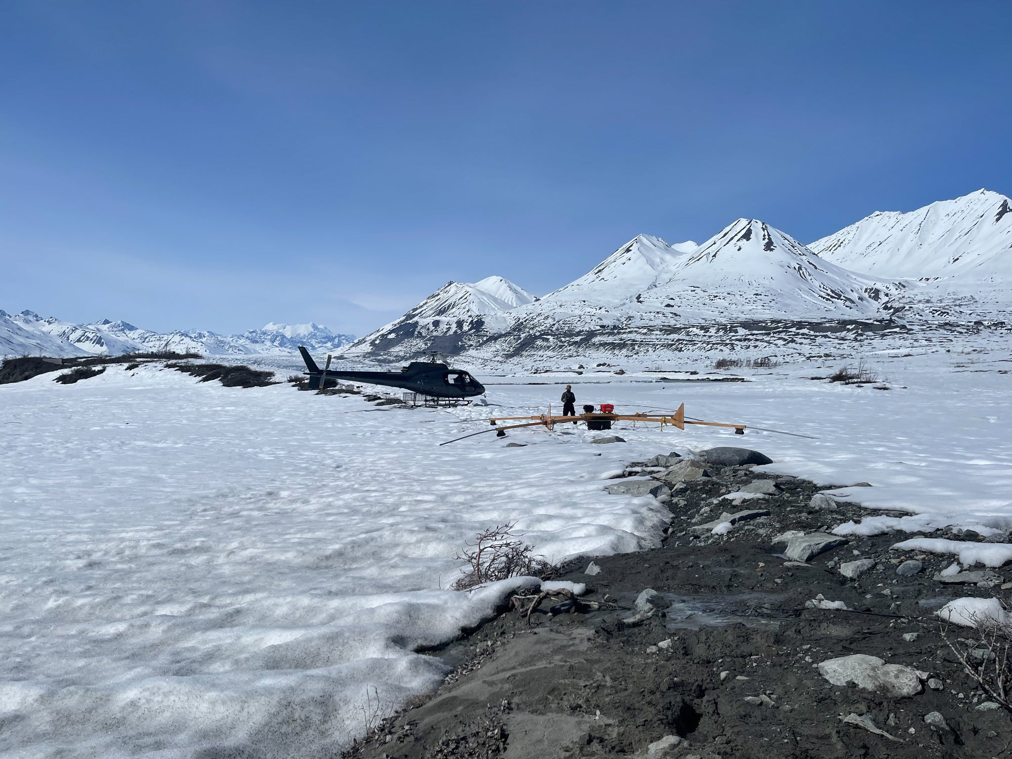
Peter Wray near Lowell Glacier ready to help the helicopter pilot launch the radar system and start a survey.
This research marks a milestone in Canadian glaciology. Unlike temperate glaciers in Western Canada, which are rapidly vanishing, the melting of the St. Elias glaciers will continue to influence global sea level rise and local ecosystems well after 2100. Understanding their behaviour requires accurate, high-resolution models of their geometry and bedrock interface. The AirIPR system has provided precisely that enabling researchers to uncover the secrets of surge-type glaciers-those that alternate between years of slow movement and sudden, dramatic advances.
The implications of this research extend far beyond the glaciers themselves. As glacier retreat continues to accelerate in response to climate change, meltwater production from the St. Elias Mountains will affect downstream ecosystems, Indigenous communities, and hydrological systems. The team's models will help forecast when "peak water" will occur-the point at which annual meltwater production reaches a maximum and then begins to decline-a critical threshold for water resources planning. Their findings provide essential information and timelines for policymakers and conservation efforts, as the researchers collaborate with Parks Canada and local First Nation communities to ensure this knowledge informs decision-making and environmental stewardship.
"Surge-type glaciers are like sleeping giants," explains Dow. "Their unpredictable behavior poses risks to ecosystems and communities downstream. Our work provides the foundational data needed to model these dynamics and better predict their impacts."
This research also addresses the growing threat of glacial hazards, such as the rapid glacial lake floods from Dan Zhur (Donjek) Glacier. This glacier surges every 10 to 12 years, blocking a river and causing a lake to form. As the glacier retreats, the lake grows until it eventually drains rapidly, leading to downstream flooding and damage to ecosystems. Identifying future glacial lake hazards will equip local governments and surrounding communities with insights to mitigate these threats.
"Within Canada, we have a massive, largely unquantified, and rapidly changing freshwater resource, and while it is already impacting local communities it is also globally significant. As more and more regions around the world quantify the potential for global sea level rise from melting glaciers, it has become imperative that we as Canadians step up and do our part, especially when you consider that we have about 40 per cent of the world's glacierized surface area outside of Greenland and the Antarctic," Wray reflects.
"Measuring ice volume and geometry of the St Elias glaciers also presents a unique opportunity, because it houses the world's highest density of surge type glaciers whose underlying mechanisms largely remain a mystery. The hope is that by presenting the first comprehensive inventory of surge type glacier geometries, we will be able to learn about the often-unobservable glacier dynamics that are obfuscating global sea level rise predictions from high interest areas like the Western Antarctic Ice Sheet", says Dow.
As we commemorate World Water Day 2025, the research in the St. Elias Mountains highlights the intersection of scientific innovation, environmental stewardship, and community resilience. These glaciers may be remote, but their story is a global one - closely tied to the future of water security and efforts to mitigate climate change. Join the Water Institute's World Water Day event to explore these critical issues and connect with experts shaping the future of water research.


