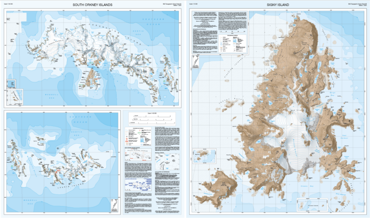
The South Orkney Islands lie roughly 650km north-east of the Antarctic Peninsula and 1250km south-east of South America. The British research station on Signy Island and the Argentine research station on nearby Laurie Island rely on precise maps to navigate the region's challenging terrain. The new maps are a significant update on previously published versions, which were produced by the Directorate of Overseas Surveys (DOS) in 1963 and by BAS in 1988. Both older maps were based on surveys conducted by the Falkland Islands Dependencies Surveys (FIDS), but are now considerably out of date and not comparable to the standard of modern maps.
Signy Island, a critical site for scientific research and home to the UK's smallest research station in Antarctica, has seen notable geographical changes since the last BAS map was created in 2010. Satellite imagery has revealed new features, including two newly named lakes: Quicksilver Lake and Jobson Lake, both formed by the retreat of the permanent ice cap on the island. Other changes on the island include expanded regions of moraine around the edges of the glaciers, left as the ice scours the landscape and retreats, and an increase in the number of ponds that come and go each year.
Another useful addition to the new map is the inclusion of bathymetry data, reproduced with permission from a UK Hydrographic Office chart. The waters to the west of the island are still unsurveyed however, due partly to the treacherous nature of this region and the presence of numerous rocks. The shipwreck of an old whaling ship called the Tioga is shown on the map in Port Jebsen, where it was wrecked in 1913.
The map of the whole South Orkney Island group shows a similar story to the Signy map, but over a much larger area. The ice has retreated around the coastline, creating new islands and exposing rocks in the water that were previously covered by the ice. Many areas of exposed rock outcrop and moraine have also been revealed on land as ice retreats and melts. The accurate location of these exposed rocks are important for anyone traversing over the land, and for identifying locations in a satellite image. New mountain spot heights were calculated for the maps, using the most recently available high-resolution elevation data. Some of the peaks were more than 200m taller than previously thought, with Worswick Hill changing from 575m to 794m.
Bathymetry depths are also shown on this South Orkneys map, with the data reproduced from an Argentinean hydrographic chart, with permission from the Servicio de Hidrografía Naval (SHN - the Argentine Hydrographic Service).
This new map is available in two formats: a folded version with a card cover and a flat version suitable for wall display. It joins the 'BAS Topographic Series' and can be purchased from various online retailers, including Stanfords and NHBS.


