A late-season major hurricane Milton poses an extremely serious threat to Florida, in a state which is still reeling from the disastrous hurricane Helene less than 2 weeks ago, killing more than 200 people. Milton will make landfall in Florida on the evening of 9 October local time.
The Florida governor's office declared a state of emergency for affected areas and mass evacuations were underway.
According to the US National Hurricane Center (NHC), "Milton has the potential to be one of the most destructive hurricanes on record for west-central Florida."
"Preparations to protect life and property, including being ready for long-duration power outages, should be rushed to completion," it said.
Milton, the ninth hurricane of the 2024 Atlantic hurricane season, rapidly intensified into a Category 5 storm in the Gulf of Mexico on Monday, October 7, 2024.
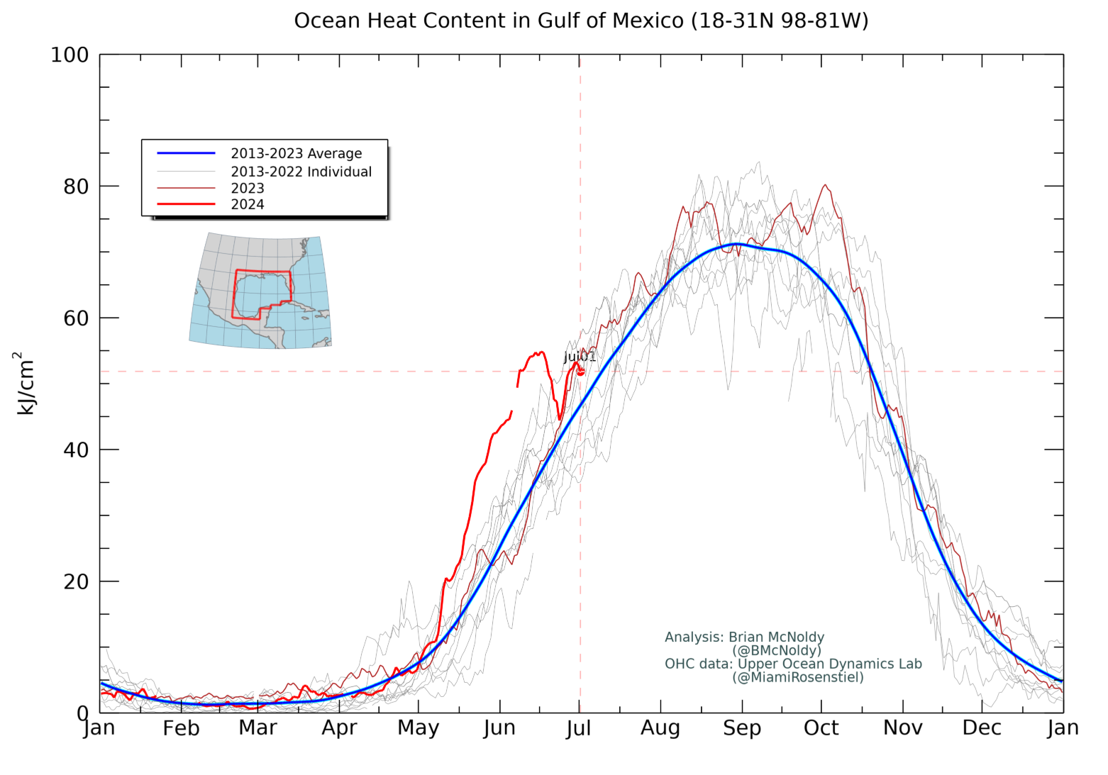
The storm exploded in strength and intensity at near record pace becoming one of the most intense hurricanes on record in the Atlantic basin. This explosive strengthening was fuelled in part by record to near-record warmth across the Gulf of Mexico. The warmer the ocean is, the more fuel there is for hurricanes to intensify, provided other atmospheric conditions (like wind shear) are also favourable.
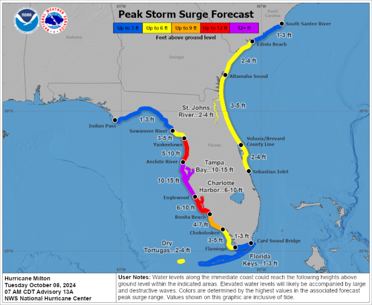
A large area of destructive storm surge, with highest inundations of 10 feet (3 meters) or greater, is expected along a portion of the west-central coast of the Florida Peninsula, including in densely populated areas such as Tampa Bay, according to the US National Hurricane Center.
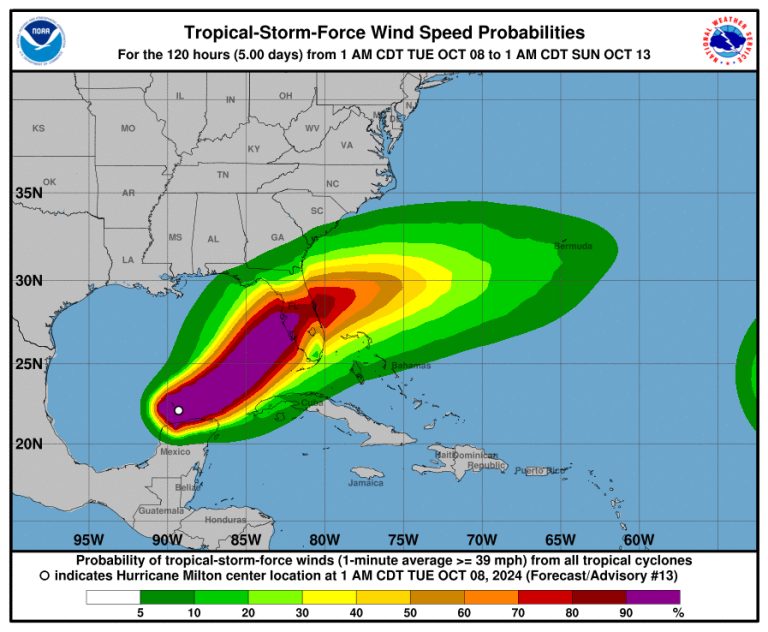
It warned of devastating hurricane-force winds, with heavy rainfall and the risk of catastrophic and life-threatening flash and urban flooding.
Milton is also a large hurricane, with hurricane-force winds extend outward up to 30 miles (45 km) from the centre and tropical-storm-force winds extend outward up to 80 miles (130 km). It is expected to grow in size.
Milton will make landfall in Florida, just as Helene did 10 days ago, but at a different location (in the Fort Meyers area, close to where Hurricane Ian made its landfall in 2022). Ian was also category 5. Then, Milton is expected to cross Florida State and exit into the Atlantic Ocean.
There are currently three hurricanes spinning in the Atlantic - Milton, Leslie and Kirk. This is quite exceptional for the month of October.
Kirk weakened from a category 1 hurricane and became an ex tropical cyclone as it hit Europe on Wednesday.
The major impacts will be in France. Meteo-France forecast wind gusts up to 110 km/h at the coast and up to 90 km/h inland, and heavy rainfall , from Loire region to Lorraine region, including Paris area.
Role of climate change
A group of international scientists in World Weather Attribution found that climate change was a key driver of catastrophic impacts of Hurricane Helene that devastated both coastal and inland communities.
It said climate change is enhancing conditions conducive to the most powerful hurricanes like Helene, with more intense rainfall totals and wind speeds and cited findings that Atlantic tropical cyclones are becoming wetter under climate change and undergoing more rapid intensification.
Hurricane Beryl - the earliest Category 5 hurricane on record in July 2024 - also underwent rapid intensification, as have other recent tropical cyclones.
To determine the role of climate change in the rainfall, the World Weather Attribution team combined observations with climate models. In both regions, the rainfall was about 10% heavier due to climate change, and equivalently the rainfall totals over the 2-day and 3-day maxima were made about 40% and 70% more likely by climate change, respectively.
"If the world continues to burn fossil fuels, causing global warming to reach 2 °C above pre industrial levels, devastating rainfall events in both regions will become another 15-25 % more likely," it said.
Hurricane Helene was very well forecast with the national agency NOAA urging media to warn people of "catastrophic and life-threatening" flooding and landslides across the Southern Appalachians. People in affected coastal regions were asked to evacuate ahead of the landfall of Helene. However, most of the deaths occurred farther inland, in the mountainous terrain where challenges such as spotty cell and internet services, limited experience with Hurricanes and more limited evacuation infrastructure have been reported in the media as leaving people feeling caught off guard.


