Key points:
- The Bureau of Meteorology (BOM) has announced that La Niña conditions have ended and El Niño–Southern Oscillation (ENSO) neutral conditions can be expected for the rest of autumn.
- Drier and hotter conditions are expected for the remainder of autumn and into winter.
- There is reduced restocker sentiment in southern states, along with larger yardings across sheep and cattle.
BOM's outlook for autumn
Despite flooding conditions in northern Australia, the Bureau of Meteorology (BOM) has issued a statement that La Niña has officially ended in the tropical Pacific Ocean and has returned to El Niño–Southern Oscillation (ENSO) neutral conditions.
Neutral ENSO conditions are likely to continue throughout the southern autumn – however, there are some signs that an El Niño could form later in the year. The BOM have issued an El Niño watch, indicating a 50% chance of an El Niño in 2023.
Warmer waters around the south-east of Australia can cause greater evaporation, humidity and rainfall in some areas. Overall, hotter and drier conditions can be expected for the end of March as the Madden-Julian Oscillation (MJO) is forecast to move into the Atlantic Ocean in the next few weeks.
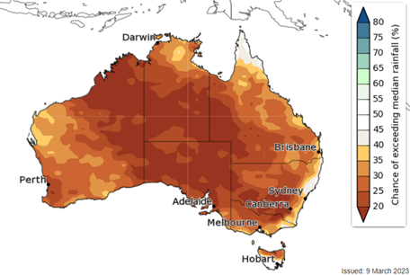
The outlook for the next three months looks drier than average (Figure 1). Most areas should expect a low chance of exceeding median rainfall.
Figure 1: Three-month rainfall outlook April – June 2023

Source: Australian Bureau of Meteorology
Temperatures are another indication of the conditions to expect in the coming months. The BOM has forecast the majority of Australia to exceed median maximum temperatures in the next three months (Figure 3). This increases evaporation and fire risk, as well as reduces grass growth.
Figure 3. Change of above median maximum temperature April – June

Source: Australian Bureau of Meteorology
This outlook is much the same out to July as the ENSO-neutral conditions set in.
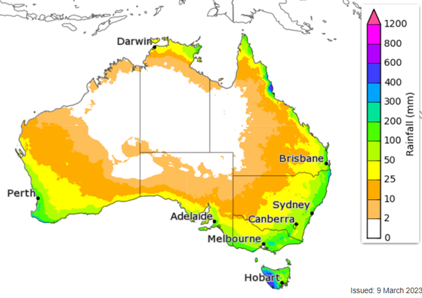
Recent flooding conditions from a tropical low in the Gulf Country in north-west Queensland has dumped 2.5–5 times more than the March average rainfall in these areas. The highest weekly rainfall measured was 609.6mm of rain at Century Mine, which also recorded the highest daily total of 313.4mm. These rainfall events have caused a tightening of supply in Queensland as access to markets have either been put off or are greatly limited. Stock losses in the area are expected.
What this outlook means for producers
Weather is a key indication of producer decision making. Hot and dry conditions for the remainder of autumn and an ending of the favourable conditions that came with La Niña could see some producers selling off cattle.
In recent weeks, the market has seen a softening in restocker sentiment in southern states, with premium prices for the Restocker Yearling Heifer and Restocker Yearling Steer only seen in Queensland. This could be partly attributed to producers' restocking needs being met by their 2022 calf drops.
The southern rebuild kicked off sooner than in northern areas, so an earlier easing in restocker sentiment can only be expected.
Sheep and cattle yardings are also expected to lift in the coming months as young cattle and lambs come to weight from three successful seasons. Older ewes and cows that have underperformed or were cast for age could also be sold as the rebuild matures and producers prepare for drier conditions.
Successive favourable seasons have ensured a mostly full moisture profile for large parts of the country. This profile will support continued pasture growth aided by rainfall when it eventuates. Improved moisture availability and plentiful water supplies should see retention and confidence in on-farm carrying capacity continue as the herd and flock growth matures.


