5 min read
- More than 100 scientists will participate in a field campaign involving a research vessel and two aircraft this month to verify the accuracy of data collected by NASA's new PACE satellite: the Plankton, Aerosol, Cloud, ocean Ecosystem mission.
- The process of data validation includes researchers comparing PACE data with data collected by similar, Earth-based instruments to ensure the measurements match up.
- Since the mission's Feb. 8, 2024 launch, scientists around the world have successfully completed several data validation campaigns; the September deployment - PACE-PAX - is its largest.
From sea to sky to orbit, a range of vantage points allow NASA Earth scientists to collect different types of data to better understand our changing planet. Collecting them together, at the same place and the same time, is an important step used to verify the accuracy of satellite data.
NASA's Plankton, Aerosol, Cloud, ocean Ecosystem (PACE) satellite launched in February 2024 and is collecting observations of the ocean and measuring atmospheric particle and cloud properties. This data will help inform scientists and decision makers about the health of Earth's ocean, land surfaces, and atmosphere and the interactions between them.
To make sure the data from PACE's instruments accurately represent the ocean and the atmosphere, scientists compare (or "validate") the data collected from orbit with measurements they collect at or near Earth's surface. The mission's biggest validation campaign, called PACE Postlaunch Airborne eXperiment (PACE-PAX), began on Sept. 3, 2024, and will last the entire month.
"If we want to have confidence in the observations from PACE, we need to validate those observations," said Kirk Knobelspiesse, mission scientist for PACE-PAX and an atmospheric scientist at NASA's Goddard Space Flight Center in Greenbelt, Maryland. "This field campaign is focused on doing just that."
Scientists will make measurements both from aircraft and ships. Based out of three locations across California - Marina, Santa Barbara, and NASA's Armstrong Flight Research Center in Edwards - the campaign includes more than 100 people working in the field and several dozen instruments.
"This campaign allows us to validate data for both the atmosphere and the ocean, all in one campaign," said Brian Cairns, deputy mission scientist for PACE-PAX and an atmospheric scientist at NASA's Goddard Institute for Space Studies in New York City.
On the ocean, ships, including the National Oceanic and Atmospheric Administration (NOAA) research vessel Shearwater, will gather data on ocean biology and the optical properties of the water. Scientists onboard will gather water samples to help define the types of phytoplankton at different locations and their relative abundance, something that PACE's hyperspectral Ocean Color Instrument measures from orbit.
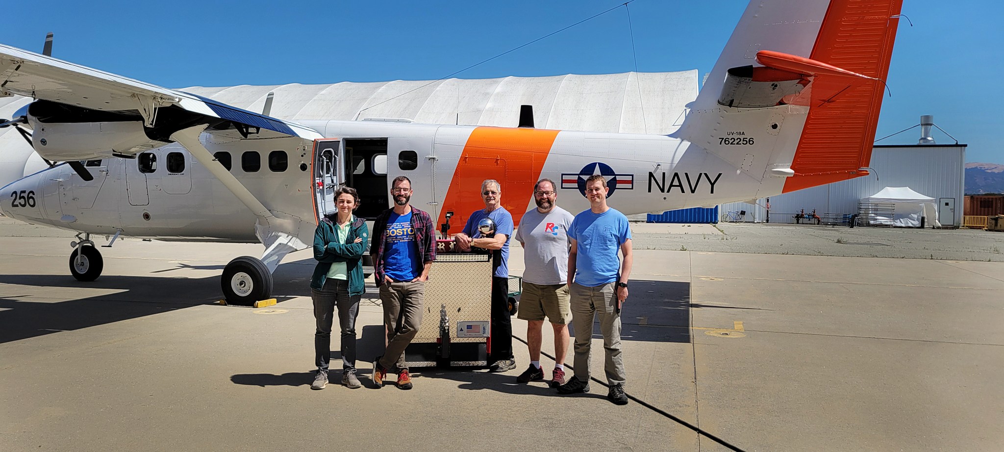
Overhead, a Twin Otter research aircraft operated by the Naval Postgraduate School in Monterey, California, will collect data on the atmosphere. At altitudes of up to 10,000 feet, the aircraft will sample and measure cloud droplet sizes, aerosol sizes, and the amount of light that those particles scatter and absorb. These are the atmospheric properties that PACE observes with its two polarimeters, SPEXOne and HARP2.
At a higher altitude - approximately 70,000 feet up - NASA's ER-2 aircraft will provide a complementary view from above clouds, looking down on the atmosphere and ocean in finer detail than the satellite, but with a narrower view.
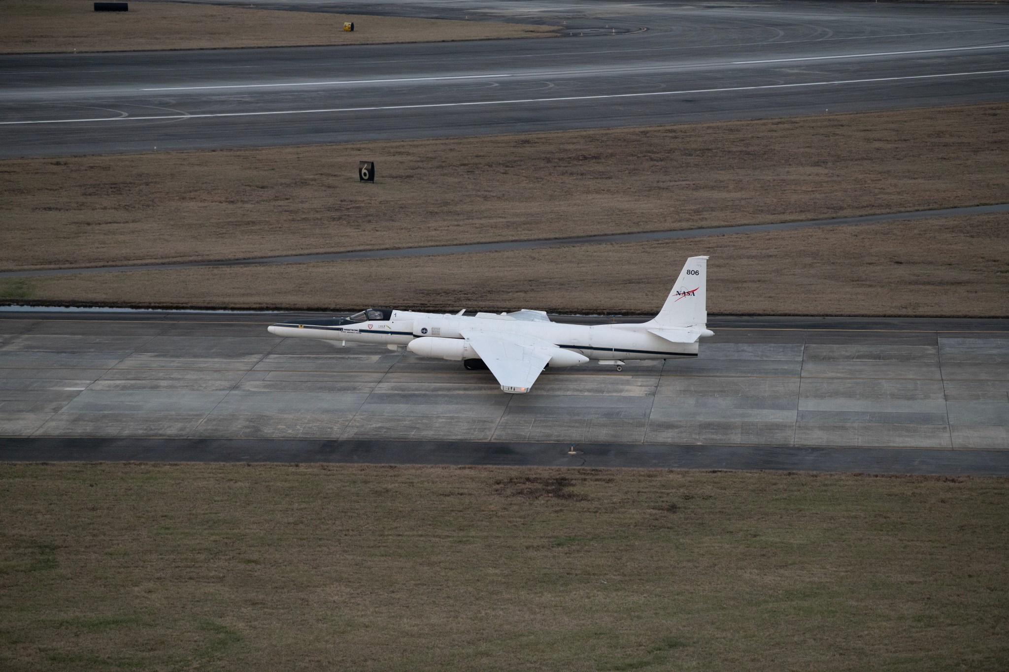
The plane will carry several instruments that are similar to those on PACE, including two prototypes of PACE's polarimeters, called SPEXAirborne and AirHARP. In addition, two instruments called the Portable Remote Imaging SpectroMeter and Pushbroom Imager for Cloud and Aerosol Research and Development - from NASA's Jet Propulsion Laboratory in Pasedena, California, and NASA's Ames Research Center in California's Silicon Valley, respectively - will measure essentially all the wavelengths of visible light (color). The remote sensing measurements are key for scientists who want to test the methods they use to analyze PACE satellite data.
Together, the instruments on the ER-2 approximate the data that PACE gathers and complement the in situ measurements from the ocean research vessel and the Twin Otter.
As the field campaign team gathers data, PACE will be observing the same areas of the ocean surface and atmosphere. Once the campaign is over, scientists will look at the data PACE returned and compare them to the measurements they took from the other three vantage points.
"Once you launch the satellite, there's no more tinkering you can do," said Ivona Cetinic, deputy mission scientist for PACE-PAX and an ocean scientist at NASA Goddard.
Though the scientists cannot alter the satellite anymore, the algorithms designed to interpret PACE data can be adjusted to make the measurements more accurate. Validation checks from campaigns like PACE-PAX help scientists ensure that PACE will be able to return accurate data about our oceans and atmosphere - critical to better understand our changing planet and its interconnected systems - for years to come.
"The ocean and atmosphere are such changing environments that it's really important to validate what we see," Cetinic said. "Understanding the accuracy of the view from the satellite is important, so we can use the data to answer important questions about climate change."
NASA's Goddard Space Flight Center, Greenbelt, Md.