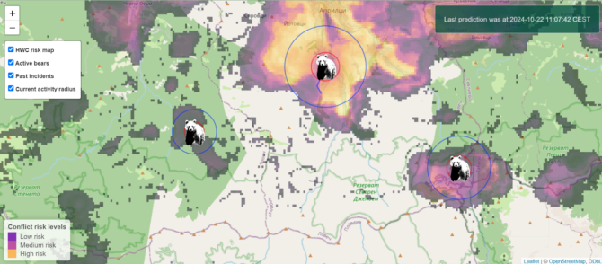
As human populations expand and climate change disrupts natural habitats, the Eurasian brown bear increasingly conflicts with people. A new technology offers new possibilities: the Human-Bear Conflict Radar. This online tool, which Wageningen University & Research developed, combines modelling with real-time data to predict bear movements and reduce conflict situations. The prototype is now online and being tested in Bulgaria.
This new tool could change how we manage human-wildlife conflict. The Human-Bear Conflict Radar is an innovative digital twin prototype designed to monitor and predict conflicts between humans and bears in real-time. Developed as part of the Nature FIRST project, this tool aims to provide timely information to support conflict prevention. It is one of the first digital twin prototypes to be developed in ecology.

Charged debate
The Eurasian brown bear (Ursus arctos arctos) is a large, highly adaptable omnivore increasingly being driven into conflict with humans due in part to climate change, habitat fragmentation and elevated numbers of humans in bear habitat. These formidable animals often cause property damage when they venture near human settlements searching for food, such as beehives, livestock and fruit trees. This is thought to be motivated by a lack of natural food sources.
They can also pose a direct danger to humans, as illustrated by the recent death of a man after a bear attack in Slovakia. Recent years have seen a rise in the number of bear attacks. Such tragedies make the issue of conflict between humans and bears especially emotionally charged. This has, in turn, led to the approval of controversial measures such as increasing bear culls or targeted hunts of so-called "problem bears", which have both been heavily contested by ecologists for a myriad of reasons.
Real-time solutions
The Human-Bear Conflict Radar was developed to support the work of conservationists and bear response teams in implementing interventions that reduce conflict without endangering local bear populations. This tool works with real-time reports of human-bear conflict, which are entered into the radar using a data collection app called Cluey. The radar then displays the active bear's last known location and a predicted movement radius, which helps bear response teams locate the bear if, for example, it needs to be relocated. The radar also uses this real-time information to forecast conflict risk in the local area to the active bear, given historical data available on human-bear conflict and local bear habitat information.
The Human-Bear Conflict Radar is a type of model called a digital twin. It is unique from other models due to its link with real-time data. This allows the model to automatically update its information as soon as data is collected, rather than waiting for a researcher to analyse it, as with most other models. For this reason, digital twins have the potential to be powerful tools for conservationists and other wildlife management organisations. They can provide up-to-date information even for rapidly changing systems.
Digital twins in ecology
Digital twins were initially used in manufacturing and engineering. Anna Davison is doing her PhD research on using digital twins in ecology. According to her, the Human-Bear Conflict Radar is a significant step towards their more widespread use. 'The application of digital twins in ecology is an exciting emerging field to work in, due in no small part to the focus on building these tools to tackle pressing issues. We have learnt a lot about the process of building digital twins in collaboration with our field partners during the Nature FIRST project. I look forward to expanding on that work over the last couple of years of my PhD.'
Currently, the Human-Bear Conflict Radar is only available to the bear team from the Bulgarian Academy of Sciences, who are involved in the Nature FIRST project. This is to test the predictions of this tool further and protect sensitive data. Planned developments include improving the forecast of bear risk using expert knowledge of bear ecology, such as hibernation triggers, and real-time signs of bear presence, such as footprints and scat data. The possibility of making the conflict forecast from the radar available to local communities is also being explored to support "bear smart communities" - community-led initiatives that reduce conflict in a way that benefits humans and bears.


