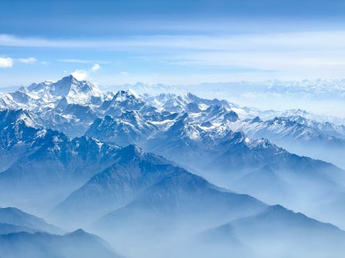
Mount Everest (also known as Chomolungma or Sagarmāthā) is famously the highest mountain in the Himalayas and indeed on Earth. But why?
Author
Gordon Lister
Visiting Professor, Sustainable Minerals Institute, The University of Queensland
At 8,849 metres above sea level, Everest is around 250m taller than the other great peaks of the Himalayas. It is also growing by about 2mm each year - roughly twice as fast as it has been growing on average over the long term.
In a new paper published in Nature Geoscience, a team of Chinese and English scientists say Everest's anomalous height and growth have been influenced by the Arun River, which flows through the Himalayas. They argue that the river's course changed around 90,000 years ago, eroding away rock that was weighing Everest down - and the mountain has bounced up in response, by somewhere between 15 and 50m.
The authors make a case for the river's contribution, but they acknowledge the "fundamental cause" of the peak's size is the tectonic processes that create mountains. To understand what's going on, we need to understand the forces that made the Himalayas in the first place, and the movements that let them grow so high.
The Tibetan blob
In the 19th century, British surveyors showed that the southern boundary of the Himalayan mountains accurately describes an arc that aligns precisely with a small circle on Earth. This is pretty amazing.
The only rational way it can be explained is if we have the Eurasian tectonic plate to the north, the Indian plate to the south, and in between a viscous mass (Tibet) spreading southwards as it slowly collapses under the force of gravity.
Deep down, the Tibetan plateau must be like hot syrup, with a cold crust at the higher levels displaying faults and earthquakes as it is pushed around by the slow northerly advance of the Indian tectonic plate. The exact nature and depth of this hot syrup is a matter of some debate, with geologists comparing it variously to creme brûlée and a jelly sandwich.
Overall, the collision of India and Eurasia is marked by a "megathrust fault", where the Indian plate is gradually sliding under the Eurasian plate. The whole megathrust doesn't move at the same time. In general, it lurches forward bit by bit in a series of "thrust earthquakes".
Where the spreading mass of Tibet makes contact with India, we see a narrow band of these thrust earthquakes. It is what happens in that narrow band that ultimately determines the elevation of the world's highest mountain.
How mountains rise (and fall)
Why is the Tibetan Plateau, to Everest's north, so flat, whereas mountains abound next to this narrow band of quakes, where the collapsing mass couples with the advancing Indian subcontinent?
The answer lies in the way that the mass of a mountain is supported.
Imagine a mountain as a pile of rubble on a thin plastic table. There is no inherent strength in the tabletop, so it sags downwards and the pile of rubble sinks. Much like an iceberg, only a part of the mass sticks up.
Νow imagine a thicker strong plate at the edge of the table. Here the pile of rubble is supported by the flexural strength of the plate, so it can rise much higher above the surface. So here mountains can be far higher. This is what happens where one tectonic plate slides over another, as the downgoing plate creates a stronger region.
Naturally there is a balance. When the movement of tectonic plates causes earthquakes, the mountain tops can shatter and giant avalanches will move the fallen rock into the adjacent river systems.
The fall of this rubble may reduce the mountains' absolute height, and also its relative height compared to neighbouring valleys - though this will depend on how efficiently rivers move the debris downstream.
In turn, when this rocky mass is moved away downstream, the upstream areas will be somewhat lighter. In our plastic table model, we might expect the table surface would bow down less and rubble peak rise a smidgen higher.
This is what the new research argues, but fundamentally it is earthquakes that push mountains higher. When the megathrust ruptures, where the tectonic plates meet, up the mountains go - though how far up they go depends on the strength of the supporting rock beneath.
What's special about Everest?
The crucial question (as indeed the authors recognise) is why does Everest stand out?
The boundary between collapsing Tibet and advancing India is defined by a giant megathrust fault. Some parts of this fault have not broken for a very long time, perhaps several centuries or more. It is likely that a lot of strain has accumulated in these areas, and when they finally break, the result will be catastrophic.
However, the part of the megathrust beneath Everest appears to break routinely, perhaps once or twice per century. The last big earthquake there partly involved an existing rupture.
With each break, it is likely that Everest grows a little higher. Hence it's no wonder that Everest is able to maintain its superiority in comparison to peaks in quieter parts of the megathrust.
As the new research suggests, rogue rivers may well play a role in Everest's size - but the bulk of the mountain's greater height still seems likely due to the pattern of quakes along the Himalayan fault.
The difficulty for the scientists involved is how to separate the individual contributions to height from different factors. One is erosional rebound, as the new research suggests, but there are also tectonic processes such as movement on the Main Central Thrust, or slow creep on the South Tibetan Detachment Fault beneath which Earth's highest mountain has been exhumed.
![]()
There is nothing to disclose.


