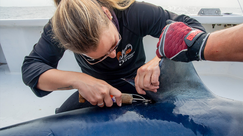
Laura McDonnell, a doctoral candidate in the Abess Center for Ecosystem and Science, has attached dozens of high-tech sensors to blue and mako sharks in the Gulf Stream, turning them into animal oceanographers that help record information scientists can use to study the oceans.
As the first streams of satellite data appeared on her computer monitor, University of Miami marine scientist Laura McDonnell thought one of the datapoints she began to analyze was an error—1,496 meters, the number read.
That's how deep one of the oceanographers McDonnell had recruited to help her study the Gulf Stream had dived off the coast of Cape Cod.
Could it be? A nearly mile-deep descent without the use of a deep-sea submersible?
The number, as she would later confirm, was spot on. What would surely be a fatal dive for any human was all in a day's work for her oceanographer friend—one of the millions and near-threatened blue sharks in the world that are capable of diving to extraordinary depths.
For the past two years, McDonnell, as part of an effort to help researchers learn more about the health of our oceans, has harnessed the remarkable diving prowess of blue sharks and shortfin makos, attaching sophisticated satellite tags to their dorsal fins that record information on temperatures throughout the water column.
"For the longest time, that's what's been missing from ocean observation studies—high-resolution temperature readings at extreme depths in near real-time," said McDonnell, a doctoral student at the University's Abess Center for Ecosystem Science and Policy. "Argo floats, which go down and pop back up and give you information about the water column, could be deployed. But they tend to get pushed out of areas like the Gulf Stream that have high frontal energy and where the waters move quickly or there are eddies and other ocean processes that create more turbulent conditions," she explained.
Ships, submersibles, moored buoys, and other ocean-monitoring instruments also have their limitations, McDonnell added.
But blues and makos face no such restrictions. Among the strongest swimmers in the ocean, they migrate down the Gulf Stream each fall, regularly diving deep during their journey. So, to get the much-sought-after data scientists covet, McDonnel figured, "Let's tag the sharks."
And she did, starting in the fall of 2021, when she and a team of other scientists, including renowned shark researcher and University of Miami alumnus Neil Hammerschlag, traveled to Cape Cod in Massachusetts for a weeklong shark-tagging expedition. They returned to the Cape a year later to tag more sharks.

"I like to think of the sharks we tag as our own team of oceanographers," McDonnell said.
Over her two deployments off Cape Cod, she and her team tagged 29 blue and mako sharks in all, catching them with sturdy fishing rods, then hoisting them onto the back of a boat, where the researchers would record their length and collect blood and tissue samples before attaching the critical satellite tags.
"It's the location, depth-specific, and temperature-depth profiles in the Gulf Stream we care most about," she said. A strong ocean current that transports warm water from the Gulf of Mexico into the Atlantic, the Gulf Stream extends up the eastern coast of the U.S. and Canada, influencing the climate of coastal areas and to a greater degree the climate of northwest Europe.
The tags McDonnell deploys, which eventually detach from the sharks' dorsal fins, were custom made to transmit important data on the Gulf Stream waters to an orbiting satellite each time a shark surfaces.
McDonnell has already analyzed the more than 8,000 profiles from the 2021 trip, making those numbers available to researchers who may need them.
One of them is Ben Kirtman, a professor of atmospheric sciences at the Rosenstiel School of Marine, Atmospheric, and Earth Science. He has used McDonnell's shark-tagging data to enhance his weather models, including his Subseasonal Experiment, which combines a multitude of models to create real-time forecasts three to four weeks into the future.
"We have good satellite data of surface temperature, but it's the temperature at depth that we don't have very good information on. And that's where Laura's data has been most useful. We've used a bunch of it to initialize our climate system forecasts," Kirtman said. "We still must conduct more experiments to show that the data improves our forecasts, but we have proved that it reduces the systematic errors."
The tags McDonnell deployed last September recently stopped transmitting, and she will soon start poring over those numbers.
"We're in a golden age of marine animal tracking," she said. "Sharks, whales, seals—there are so many tagged species swimming where they normally swim and doing what they normally do. Why would we not collect more information from them?" she asked. "It's an incredible opportunity to gather oceanographic data that scientists in various research disciplines can use. And we can customize the tags based on the needs of whoever's going to be using them."
Her data, for example, could also help marine biologists study the movement and migration patterns of sharks. During the past several decades the Northeast U.S. continental shelf has been warming faster than any of the nation's other ocean regions. "And that's had an impact on tiger sharks," McDonnell said.
The annual migration patterns of some of those sharks, which prefer warm water, has shifted poleward and occurred earlier because of rising ocean temperatures. "They're leaving protected areas, which makes them vulnerable to commercial fishing," McDonnell said. "It can be difficult to conceptualize how large the global ocean is and how interconnected it is. What happens in one place will affect areas somewhere else. Tagging certain species keeps us informed."


