How's the snow on Northwest mountains this year? Overall a little deeper than normal, but it depends where you look. A new collaboration between the University of Washington, the Northwest Avalanche Center lets you see how the current snow depth compares to past years for nine sites in Washington and two in Oregon.
The new mountain snow depth tool is freely available on the Office of the Washington State Climatologist's website. It replaces a tool made more than a decade ago that collected snow depth data from the NWAC website to create a simple graphic on the state climatologist's website.
"When that display wasn't working, that's the one where we would get emails from ski enthusiasts or other meteorologists or climatologists. To us that was a good sign that we should rebuild it," said Karin Bumbaco, a UW research scientist who is the assistant state climatologist.

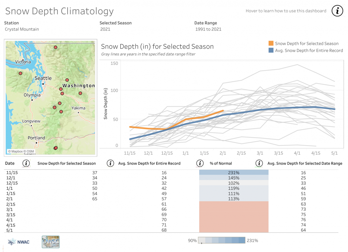
This shows the snow depth at Crystal Mountain this year (orange line) compared to the average for that date (blue line). Gray lines show the past 30 years of measurements. This year is slightly above average for many of the 11 mountain stations (red dots on map), listed alphabetically in the station dropdown menu.Northwest Avalanche Center/Washington State Climatologist/Tableau
The new version, built with support from Tableau, is interactive, displays more data and is more reliable. It lets users explore differences in mountain snow depth from one season to the next and create a graphic of the results.
"This is a tool that people in the weather community, like meteorologists and climatologists, as well as snow recreationalists, can use to communicate the current snow conditions and how they relate to average conditions and previous years," Bumbaco said.
A default view shows the current year compared to the past 30 years of data at a single location. Changing the settings can display measurements back as far as 1927 for the longest-running stations, on Mount Baker at Paradise on Mount Rainier. Measurements go back to 1974 for the two most recent stations, at Mount Hood Meadows and Timberline in Oregon.

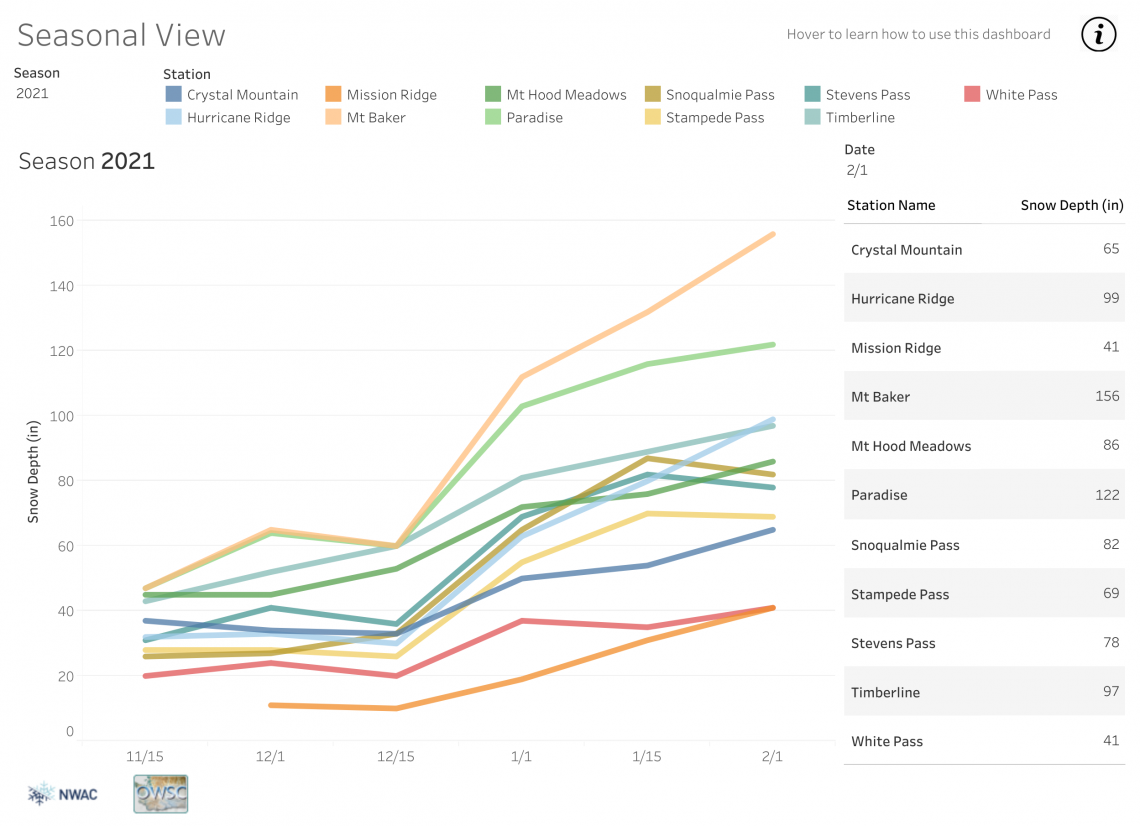
The seasonal view shows the current winter's snow depth measurements at all locations up to Feb. 1, 2021. Mt. Baker has the deepest snow (orange line), with Paradise at Mt. Rainier (green line) in second place. Most of the 11 locations are still accumulating snow depth.Northwest Avalanche Center/Washington State Climatologist/Tableau
The Northwest Avalanche Center monitors mountain snow depth for their forecasting operations as avalanches pose risk to roadways and people venturing onto the winter slopes. Data are entered 12 times a year, on the 1st and the 15th of each month, during the monitoring season from Nov. 15 to May 1.
The monitoring sites are part of the center's mountain weather station network. Some sites are owned by the Washington state Department of Transportation, while others are partnerships between NWAC and the transportation department, ski areas or national parks. While other measures exist, they don't have the same history of similar measurements.
"We use this tool to track how our snow depth is building across NWAC's forecast region in a historical context," said Dennis D'Amico, meteorologist and forecast director at the Northwest Avalanche Center, who worked on the project. "Local professionals and recreationists track this report all season long. This new tool will allow them to explore historical snow depth data in a modern visualization tool at winter recreation access points."

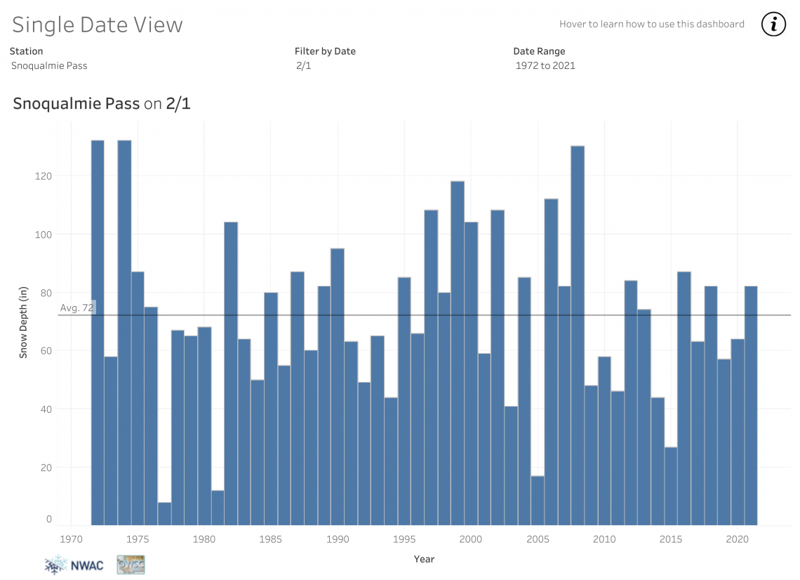
The "single date view" shows that mid-season snow depth is very variable. At Snoqualmie Pass, this year is slightly above average (black line) for the Feb. 1 measurement. The low-snow years of 2005 and 2015, and snowy years of 2006 and 2008, stand out in the recent data.Northwest Avalanche Center/Washington State Climatologist/Tableau
The new tool complements a previous UW data visualization looking at long-term weather trends. Official trends in mountain snowpack are measured in snow-water equivalent, or the amount of water when the snow is melted. Those trends vary throughout the state and generally show long-term declines of about 3%-10% per decade, Bumbaco said.
The many people seeking outdoor recreation during the pandemic are lucky that most of the 11 stations are now measuring slightly above-normal snow depth. This winter had been forecast to be an La Niña year, which is often slightly cooler and wetter in the Northwest, Bumbaco said. It's delivered on half that promise, with December-January conditions generally warmer and wetter than average.
The spring outlook continues to predict conditions slightly cooler and wetter than normal, Bumbaco said, which means we're likely to see a healthy snowpack.
The new visualization tool was supported by Tableau.


