Using satellite technology to look at how bogs "breathe" could help build a better picture of peatland condition and restoration progress in Scotland.
New research, published on International Bog Day (July 25th), demonstrates the potential for measuring "bog breathing" - or peatland surface motion – to monitor restoration sites in future.
A collaboration between the University of Nottingham, NatureScot, Forestry and Land Scotland, and University of the Highlands and Islands, the research uses Interferometric satellite radar (InSAR), which can map the movement of the ground's surface – a technique developed with University of Nottingham spinout company Terra Motion Ltd.
The way that bogs move, or breathe, can be influenced by many factors, including water level, vegetation composition, micro-topography and land management.
By measuring the motion over time, the technique is able to assess the condition of the peatland and the effectiveness of different restoration techniques on a large-scale.
If developed on a national-scale, the method could provide a better estimate of the amount and distribution of peatland and associated carbon inventories in Scotland, and a means of assessing the impact of investment in peatland restoration.
It could also help to identify areas at high-risk of peat instability, fire and erosion, and highlight where urgent restoration action might be needed.
Chris Marshall, lead author who conducted the research while at Nottingham and subsequently at the University of the Highlands and Islands, where he is now a peatland scientist, said: "Bog breathing or peat surface motion gives a unique insight into the inner workings of the peatland including its landscape, hydrology and ecology, however the high frequency of ESA sentinel-1 imagery and developments in InSAR processing techniques allows us to monitor peatland condition at a scale unimaginable a decade ago allowing peatland restoration progress to be measured in real time."
The techniques developed during this work are now being applied as part of a Leverhulme award to determine how resilient the Scotland's peatlands are to extreme climate events such as wildfire, drought and extreme precipitation events, in order to guide management of these valuable ecosystems during this period of climatic change.
Dr David Large, co-author and peatland specialist at the University of Nottingham, said: "This new tool allows us to see the landscape swell and contract in response to different environmental conditions. A healthy peatland is wet with lots of soft and spongy sphagnum mosses that swell and retain water. In contrast, drier peatlands are stiffer and unresponsive to the addition of water. The former moves like a beating heart, whereas a degraded peatland could be described as flatlining!"
This technique is really exciting because it enhances our understanding of peatlands, allowing us to see what we would not ordinarily be able to with the naked eye, making our peatlands more accessible and ensuring restoration takes place in the right place. In the future, it has the potential to be used to monitor carbon emissions."
May Shirkhorshidi, NatureScot's Peatland ACTION report manager, said: "Peatland restoration is a crucial nature-based solution to the twin crises of climate change and biodiversity loss, a key priority as we look towards the COP26 in Glasgow later this year.
"While in the early stages of development, we are excited about the long-term potential of this research, which could help Peatland ACTION to target priority areas for restoration and offer a scientifically-proven way of monitoring changes in peatland condition following restoration.
"This is a really interesting development for all the Peatland ACTION partners as it could help us evaluate the success of different restoration techniques - putting us in a better position to share this knowledge with others. Crucially it could allow us to do this more quickly and on a far larger scale across Scotland. We look forward to working with partners over the coming years to develop the concept further."

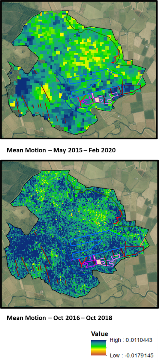
The above image shows long term trends in peat surface motion at Flanders Moss.
(Top) 5 years of data at 80m pixel resolution (03/2015-03/2020).
(Bottom) 2 years of data (12/2016-12/2018) at 20m pixel resolution, lines show restoration activities. © University of Nottingham. Contains NatureScot data and basemap data from ©Getmapping Plc Contains OS data © Crown copyright and database right (2020).


