- Curiosity Home
- Science
- News and Features
- Multimedia
- Mars Missions
- The Solar System
2 min read

Earth planning date: Monday, Sept. 16, 2024
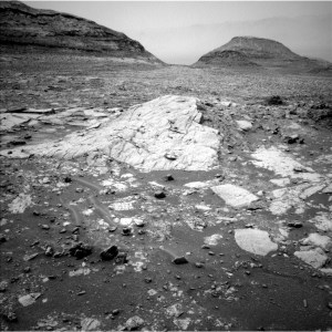
We made good progress through Gediz Vallis in the weekend drive, landing in a segment of the channel containing a mix of loose rubble and other channel-filling debris. Amongst the jumbled scene, though, particular objects of interest caught our eye: bright rocks. In past workspaces in Gediz Vallis, similar bright rocks have been associated with very high to almost pure sulfur contents. As all good geologists know, however, color is not diagnostic, so we cannot assume these are the same as sulfur-rich rocks we have encountered previously. The only way to know is to collect data, and that was a significant focus of today's plan.
We planned multiple mosaics across the examples of bright rocks visible in the image above. Mastcam and ChemCam RMI will cover "Bright Dot Lake" and "Sheep Creek" both in the right midfield of the image. Mastcam imaged the example in the bottom right corner of the image at "Marble Falls," and ChemCam LIBS targeted one of the small bright fragments along the bottom of the image at "Blanc Lake." There was also a small bit of bright material in the workspace, but unfortunately, it was not reachable by APXS. APXS analyzed a spot near the bright material, at target "Frog Lake," and MAHLI was able to tack on a few extra images around that target that should capture the bright material. MAHLI also imaged a vuggy target in the workspace at "Grasshopper Flat." The wider context of the channel was also of interest for imaging, so we captured the full expanse of the channel with one Mastcam mosaic, and focused another on mounds distributed through the channel at target "Copper Creek."
Even with all this rock imaging, we did not miss a beat with our environmental monitoring. We planned regular RAD, REMS, and DAN measurements, mid and late day atmospheric dust observations, a cloud movie, and dust devil imaging.
Our drive is planned to take us up onto one of the ridges in the channel. Will we find more bright rocks there? Or something new and unexpected that was delivered down Gediz Vallis by some past Martian flood or debris flow? Only the channel knows!
Written by Michelle Minitti, Planetary Geologist at Framework