Curious Hawkesbury residents can now help Science for Wildlife identify animals using food and water stations by watching surveillance camera footage over the internet.
If you're looking for an interesting lockdown project, this could be perfect for the whole family – and you'll be helping native animals and science at the same time. You will need a computer or mobile and an internet connection.
Following the devastating bushfires of 2019/2020, emergency assistance for wildlife included putting out water stations and food for any surviving wildlife in the fire affected bushland in the Hawkesbury and other bushfire affected areas. With funding support from their partner San Diego Zoo Wildlife Alliance, Science for Wildlife worked with local volunteers, Greater Sydney Local Land Services, WIRES, and property owners to put out water stations and do food drops for wildlife during this time.
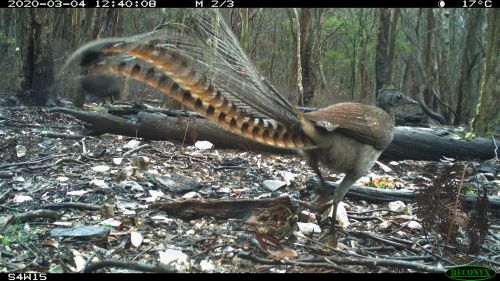
Eighty camera traps were then put in place to monitor the water and food stations to help to evaluate the emergency assistance. The idea was to capture images showing a range of animals benefiting from the stations and how many animals escaped the fires.
Water stations were placed in trees and on the ground, so you will be looking for a range of ground and tree dwelling species as well as birds. Let's see what animals you find! Just register at zooniverse.org/projects/drkellie/s4w-bushfires-water-and-food-stations to get started.
The team at Science for Wildlife would love your help to look through the camera trap images to see what can be discovered. More hot summers and droughts will come, and the findings will help to guide welfare efforts for koalas and other species during the next extreme weather event.
Here are the questions Science for Wildlife needs answered:
- Which water station designs were used, were some used more than others?
- Were the water stations still used after the heavy rains arrived?
- Which species used the water and the food drops?
- Which sites had more wildlife using the resources we put out, and how does that relate to fire intensity in that area?
- Where were feral animals present, and how many were there compared to native wildlife?
Due to the COVID-19 pandemic, the Science for Wildlife team were unable to bring the cameras back in to analyse the images and they had to leave them out for a few months. For the remainder of 2020, Science for Wildlife focused on broadscale surveys to map surviving koalas to inform population recovery. Your help will make a difference, so hop online and start looking for wildlife in action.


