 CU Boulder professor secures $800,000 NASA Grant
Khosro Ghobadi-Far is advancing the science of climate change with orbiting satellites.
Ghobadi-Far has earned an $800,000 grant from NASA to analyze data from the GRACE-FO satellites, which measure variations in Earth's gravitational field. Although gravity may appear constant to humans, it actually fluctuates across Earth's surface in ways that can be valuable to climate science.
"The variations are due to mass movement," Ghobadi-Far said. "Because of climate change and global warming, the Greenland ice sheet and Antarctic ice sheet are losing huge amount of mass, and when that mass changes, it changes the gravity field of Earth."
Ghobadi-Far is an assistant professor in the Ann and H.J. Smead Department of Aerospace Engineering Sciences and a fellow of Cooperative Institute for Research in Environmental Sciences (CIRES) at the University of Colorado Boulder. His research focuses on geodesy, the science of accurately measuring Earth's shape, gravity field, and its orientation in space as well as their variation with time.
In the early 2000s, NASA launched the GRACE satellites to observe changes in Earth's gravity field by monitoring fluctuations in the satellites' orbits using a microwave-based sensor. Ghobadi-Far used that data during his PhD thesis work to measure ice mass loss in Greenland and Antarctica, but the technology was only able to observe changes at least 300 km (186 miles) in size.
In 2018, two replacement satellites, GRACE-FO, entered service with much higher precision laser sensors. Ghobadi-Far is hopeful they can double the spatial resolution to more precisely measure ice sheet mass loss.
"It is much higher resolution data. It's very important that we understand where it is on these ice sheets that we have the largest mass loss. Why is it that this part of the ice sheet is behaving differently than another area?" he said.
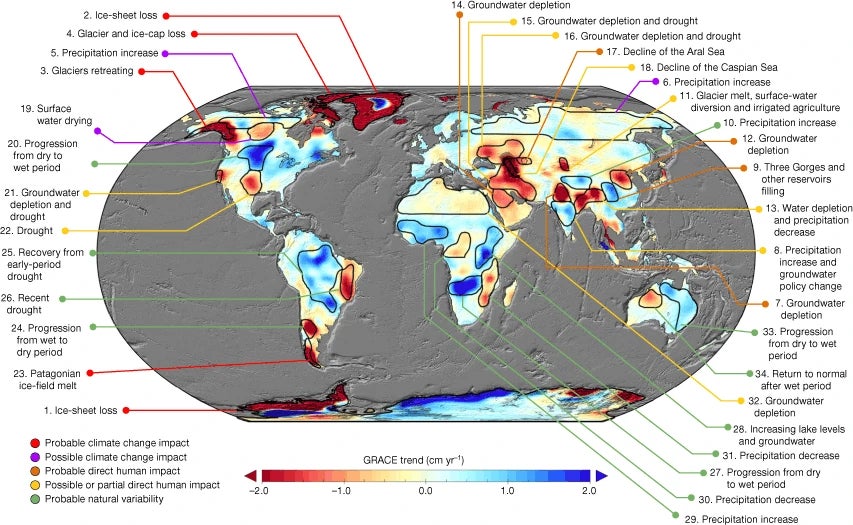
Changes in terrestrial water storage from GRACE observations from April 2002 to March 2016. Source: Emerging trends in global freshwater availability, published in Nature, May 16, 2018.
Collecting data from satellites allows researchers to track changes across the entire globe as opposed to instruments on Earth's surface that can only monitor specific locations.
"Earth is a very dynamic planet, and we'll be developing novel processing strategies to extract and exploit this laser data as much as we can to better understand how the planet is changing," he said.
The gravitational field variations are not only caused by ice sheet melt. Any large shifts in mass can be tracked, including significant groundwater pumping for agriculture and cities, movement of tsunamis, and sea level rise.
"It's really fascinating. By tracking this data over years, you can gather a lot of information," he said.
Ghobadi-Far's interest in this type of data has been growing since early in his college education. As an undergraduate, he was drawn to mathematical theories as a way to help answer complex human questions.
"I originally became interested in geodesy because of my passion for math and geometry, but I grew more and more interested in applications of space geodesy," Ghobadi-Far said. "The social impact of the work drew me to this. Geodesy allows us to use math to learn more about Earth and understand how climate change is impacting our planet."


