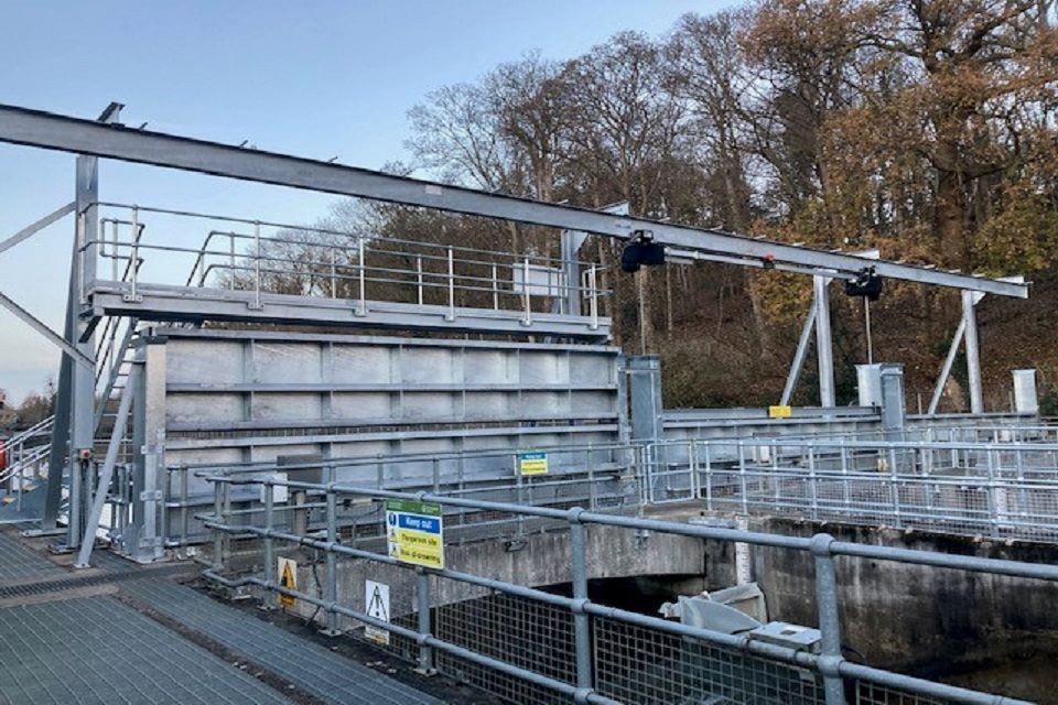
With wet weather easing off, the Environment Agency has been able to go ahead with its £1m project to install a gantry at Taplow Weir on the Jubilee flood relief channel.
The gantry is a large metal structure that bridges the channel. It allows for lowering and raising of stoplogs - horizontal steel barriers used to hold back the flow of water, which then allows testing and maintenance of the weir's sluice gates.

The impressive gantry at Taplow is a key part of flood-protection for thousands of properties in Berkshire and Buckinghamshire
The stoplogs are stacked up between metal slots on either side of the channel to create a single barrier. Previously, a large crane had to be brought onto site whenever the stoplogs needed to be used.
Eliot Beagles, the Environment Agency's leader of the team responsible for maintaining the Jubilee, said:
Along the length of the Jubilee are several weirs that keep water at levels similar to those in the River Thames.
Taplow Weir is the first and largest of these, and controls the amount of watering entering the Jubilee from the Thames, via 3 large sluice gates.
The gantry that we've just installed incorporates improved access to the sluice gates, as well as making it easier to lower and raise the stoplogs.
The project to install the gantry supports the Environment Agency's annual maintenance programme that ensures its flood defence assets remain in good working order.
Operational since 2002, the Jubilee is an 11.6km flood relief channel that reduces flood risk to 3,200 properties by diverting water from the River Thames when flows are high.
By taking excess water from the Thames, the Jubilee increases the total channel capacity in the area and reduces the level of the River Thames as it passes through Maidenhead, Windsor, Eton and Cookham. The Jubilee was used to ease high flows in the Thames as recently as January this year.
There is a 180 cumec (cubic metres per second) maximum flow capacity through the Jubilee at Taplow Weir, which is about two-thirds of the maximum flow capacity of the River Thames in this area. During the very wet winter of 2013 to 2014, the maximum flow carried in the Jubilee was 170 cumecs - or 170 tonnes of water per second.
Installing the gantry took place over 3 months over the winter, with the Envrionment Agency's contractors working around times when the Jubilee was operating as a flood relief channel. The project is now in its final testing phase, with completion expected before the end of the financial year. The total cost is expected to be £1,022,700.
The Jubilee flood relief channel is the key component of the Maidenhead, Windsor and Eton Flood Alleviation Scheme. The scheme also incorporates flood defences to the north of Maidenhead and to the west and north of Cookham.
The Jubilee flood relief channel was designed to look like a natural river, so there is always water in the channel, entering from the River Thames upstream of Boulters Lock in Maidenhead. The Jubilee then runs north of and parallel to the Thames, re-joining the river downstream of Windsor.
At times of high flows in the Thames, the Environment Agency operates control structures on the Jubilee to increase the channel's capacity, helping reduce the risk of flooding from the Thames to 3,200 properties in Maidenhead, Windsor, Eton and Cookham.
Taplow Weir controls the amount of water entering the Jubilee channel from the Thames, and consists of 3 large radial gates, all incorporating tilting flap gates. - The total capacity in both the Jubilee and the River Thames combined equates to a combined flow of 450 cumecs (cubic metres per second). The highest flow ever carried through both channels was during winter 2013 to 2014, when, over an 11-week period, the combined flow passed approximately 386 cumecs (Jubilee 162 cumecs, Thames at Maidenhead 226 cumecs). A cubic metre of water weighs approximately 1 metric tonne, or 1,000 kilogrammes. - Under normal flow conditions in the Thames, people can walk, cycle or ride horses along the 15km of paths alongside the Jubilee. Wildlife flourishes along the channel, as the naturalistic design features habitats and species found in the Thames river catchment, and includes wetlands, reedbeds, native woodland and wildflower grassland.


