Vista Gold Corp. (NYSE American and TSX: VGZ) announced that the results of its 2024 Mt Todd drilling program indicate the potential to increase gold mineral reserves in the Batman deposit and have successfully delineated the South Cross Lode ("SXL") over a 400 meter strike length. These drill results, and those from the 2020-2022 drilling program, will be included in the block model for the updated Mt Todd mineral resources estimate and new feasibility study.
This press release features multimedia. View the full release here: https://www.businesswire.com/news/home/20250203295324/en/
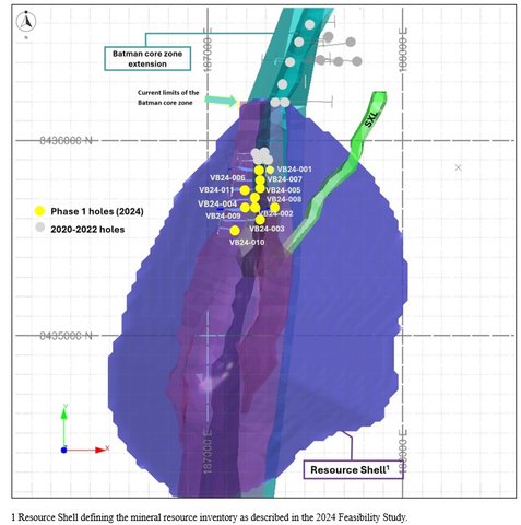
Figure 1. Phase 1 drill holes located within the current mineral resource shell and nearby holes from the 2020-2022 drilling program, showing the extension of the mineralized boundaries of the Batman core zone and relative position to the SXL zone. (Graphic: Business Wire)
Phase 1 drilling, in conjunction with the 2020-2022 drilling program, provided information to extend the boundaries of the mineralization in the northern section of the Batman deposit. As shown in Figures 2, 3, and 4, drilling intercepted gold grades higher than estimated in the current block model and mineralization outside the limits of the current resource envelope. These results provide a basis to increase gold mineral resources in the area of the Batman deposit and convert a portion of the current mineral resources in this area into proven and probable mineral reserves.
Phase 2 drilling defined the mineralized boundaries of the SXL over the strike length drilled and intersected high-grade sub-structures in the lower portion of thirteen holes, as shown in Figure 5. Additionally, the drill hole spacings are acceptable for the definition of measured and indicated mineral resources. Given the location of the SXL, these drilling results are expected to support the expansion of the mineral resource shell, with the potential to increase gold mineral reserves.
Frederick H. Earnest, President and CEO of Vista, stated, "The results of our 2024 Mt Todd drill program are encouraging. We drilled 34 diamond core holes totaling 6,776 meters and every hole intercepted mineralization, with many holes in Phase 1 encountering higher grades than estimated in the current block model. The results indicate potential to upgrade previously defined mineral resources to mineral reserves and add new mineral resources from an extension to the Batman core zone. We believe we successfully accomplished the objectives of Phase 1 of the drill program.
"The Phase 2 drilling results provide us with a much better understanding of the mineralization in the South Cross Lode. We encountered sheeted-vein mineralization consistent with the Batman deposit in the upper portions of the holes and regularly intersected more distinct, wider, and in many instances, higher grade veins deeper in the drill holes. The discovery of higher-grade and wider veins in the South Cross Lode is exciting and something that we believe merits more analysis."
Mr. Earnest concluded, "The results from the 2024 and 2020-2022 drilling programs are expected to be included in the mineral resource block model that is currently being completed as part of the recently announced Mt Todd feasibility study. Our analysis of the results of these drilling programs indicates potential to convert mineral resources to mineral reserves at the Mt Todd gold project. The new mineral resource estimate is anticipated to be announced as part of the Mt Todd feasibility study, scheduled for completion mid-2025."
Overview
Phase 1
The Phase 1 drilling was designed to augment historical data from reverse circulation ("RC") drilling and to generally improve the quality of geologic data in the northern part of the Batman deposit. The augmentation was completed through core drilling in the area just south of where drilling was completed in 2020-2022. Figure 1 shows the location of the Phase 1 and relevant 2020-2022 drill holes. The combined results of these drilling programs provide better definition of the mineralized boundaries, continuity, and limits in the north portion of the Batman deposit.
During Phase 1, a total of 11 holes were drilled in the northern end of the Batman deposit including several holes drilled outside the limits of blocks defined in the current mineral resource model. All of the holes were collared within the limits of the pit design for the 2024 Feasibility Study (as defined below). Some holes exceeded our expectations in terms of the length of mineralized intercepts and gold grade, with many intercepts having returned gold grades that exceeded block model values in the current mineral resource model. This has occurred in the past as we have replaced RC drilling data with core drilling data and further demonstrates potential to increase gold mineral reserves in the Batman deposit. See Figures 2, 3, and 4.
Phase 1 drilling is expected to result in an increase in mineral resources in the north end of the Batman deposit. Additionally, we expect this drilling to result in the conversion of inferred mineral resources to measured and indicated mineral resources within the 2024 Feasibility Study pit design. This provides further confidence that mineral reserves will be increased.
The geological characteristics observed in these holes are consistent with the rest of the Batman deposit. While we believe that the metallurgical characteristics of material in the north extension will be very similar to the rest of the Batman deposit, metallurgical testing on samples from this phase of drilling is in progress.
Phase 2
Phase 2 drilling focused on the SXL, a narrower mineralized structure adjacent to the Batman deposit, with a defined strike length of over 400 meters. The 23 holes in Phase 2 delineated the SXL mineralization identified in the data from historical RC drilling holes. The data collected from this drilling define the mineralized boundaries of the SXL structure and demonstrate the potential to increase Mt Todd mineral resources. Phase 2 drilling was conducted with adequate density and spacing to define a portion of the expected increase as measured and indicated mineral resources. Hence, we anticipate that some shallower areas may be included in mineral reserves for the 2025 feasibility study.
The drilling results revealed that the SXL is host to more discreet and, in certain zones, wider high-grade veins with thicknesses that exceed one meter, compared to the thinner, more closely spaced sheeted veins typically observed in the Batman deposit. While we anticipate that the SXL material will be amenable to processing using the same flowsheet as the ore from the Batman deposit, metallurgical testing on samples from the SXL is currently in progress.
The results from the Phase 2 drilling intersected mineralized intervals both near the surface and at depth, with exceptionally higher grades observed at depths greater than 100 meters downhole. Please refer to Figure 5 for a long section illustrating the results of the SXL drilling. These findings indicate potential for expansion in the northeastern section of the current mineral resource shell, including areas of the block model that were previously unclassified due to low data density. The SXL structure offers opportunity to increase mineral reserves, as we believe it remains open at depth and along strike to the northeast, potentially connecting with other exploration targets identified in our 2020-2022 drilling program.
Table 1. Summary of Phase 1 drill holes.
Hole No. |
Grid Coordinates |
Survey Data |
Intersections* |
|||||||||
MGA94 Grid Easting |
MGA94 Grid Northing |
RL (m) |
Azimuth (°) |
Dip (°) |
Depth (m) |
From (m) |
To (m) |
Interval (m) |
True Thickness (m) |
Grade (g Au/t ) |
||
VB24-001 |
187320 |
8435851 |
162 |
267.6 |
-55.5 |
362.2 |
41.0 |
51.0 |
10.0 |
7.8 |
0.62 |
|
and |
142.0 |
199.5 |
57.5 |
46.0 |
1.17 |
|||||||
and |
214.0 |
238.0 |
24.0 |
19.4 |
0.54 |
|||||||
VB24-002 |
187251 |
8435649 |
171 |
267.3 |
-53.8 |
341.3 |
49.0 |
67.0 |
18.0 |
14.2 |
0.49 |
|
and |
72.0 |
85.0 |
13.0 |
10.3 |
0.60 |
|||||||
and |
90.0 |
98.0 |
8.0 |
6.4 |
0.45 |
|||||||
and |
103.0 |
117.0 |
14.0 |
11.5 |
0.49 |
|||||||
and |
123.0 |
152.0 |
29.0 |
23.5 |
0.47 |
|||||||
and |
158.0 |
180.0 |
22.0 |
17.6 |
0.77 |
|||||||
and |
209.1 |
217.0 |
7.9 |
6.4 |
0.73 |
|||||||
VB24-003 |
187271 |
8435598 |
171 |
268.0 |
-54.6 |
368.3 |
53.0 |
60.0 |
7.0 |
5.4 |
0.54 |
|
and |
87.0 |
107.9 |
20.9 |
16.1 |
1.00 |
|||||||
and |
166.0 |
175.0 |
9.0 |
7.0 |
0.59 |
|||||||
and |
183.0 |
219.0 |
36.0 |
28.0 |
0.62 |
|||||||
and |
249.0 |
267.0 |
18.0 |
14.1 |
0.87 |
|||||||
and |
272.0 |
280.0 |
8.0 |
6.3 |
0.50 |
|||||||
VB24-004 |
187236 |
8435699 |
171 |
267.6 |
-54.6 |
233.4 |
69.0 |
102.0 |
33.0 |
25.5 |
0.50 |
|
VB24-005 |
187267 |
8435748 |
167 |
267.4 |
-57.8 |
290.5 |
13.0 |
22.0 |
9.0 |
6.8 |
0.46 |
|
and |
44.0 |
49.0 |
5.0 |
3.8 |
0.78 |
|||||||
and |
83.0 |
88.0 |
5.0 |
3.8 |
0.49 |
|||||||
and |
110.0 |
144.0 |
34.0 |
26.1 |
0.54 |
|||||||
and |
170.0 |
209.0 |
39.0 |
30.3 |
0.90 |
|||||||
and |
264.0 |
276.0 |
12.0 |
9.5 |
0.93 |
|||||||
VB24-006 |
187259 |
8435848 |
152 |
275.8 |
-55.3 |
212.0 |
51.0 |
88.0 |
37.0 |
29.6 |
0.44 |
|
and |
93.0 |
102.0 |
9.0 |
7.2 |
0.44 |
|||||||
and |
110.0 |
113.0 |
3.0 |
2.4 |
0.72 |
|||||||
and |
118.0 |
127.0 |
9.0 |
7.2 |
0.86 |
|||||||
and |
132.0 |
145.0 |
13.0 |
10.4 |
0.53 |
|||||||
and |
192.0 |
195.0 |
3.0 |
2.5 |
0.78 |
|||||||
VB24-007 |
187264 |
8435797 |
154 |
267.1 |
-54.9 |
220.7 |
76.0 |
101.0 |
25.0 |
20.1 |
0.49 |
|
and |
106.0 |
121.0 |
15.0 |
12.2 |
0.47 |
|||||||
and |
136.0 |
145.0 |
9.0 |
7.4 |
0.55 |
|||||||
and |
153.0 |
162.0 |
9.0 |
7.4 |
0.48 |
|||||||
VB24-008 |
187346 |
8435658 |
158 |
261.7 |
-55.0 |
422.4 |
141.0 |
145.0 |
4.0 |
3.1 |
0.92 |
|
and |
217.0 |
221.2 |
4.2 |
3.4 |
0.87 |
|||||||
and |
255.0 |
277.0 |
22.0 |
17.8 |
0.44 |
|||||||
and |
282.0 |
294.0 |
12.0 |
9.9 |
1.13 |
|||||||
and |
299.0 |
305.0 |
6.0 |
5.0 |
0.72 |
|||||||
and |
311.0 |
381.0 |
70.0 |
58.8 |
0.76 |
|||||||
including |
363.6 |
381.0 |
17.4 |
14.6 |
1.51 |
|||||||
and |
391.0 |
394.0 |
3.0 |
0.8 |
0.81 |
|||||||
and |
400.0 |
410.0 |
10.0 |
0.5 |
0.45 |
|||||||
VB24-009 |
187191 |
8435657 |
171 |
268.8 |
-57.2 |
210.3 |
7.0 |
25.0 |
18.0 |
13.6 |
0.86 |
|
and |
30.0 |
42.0 |
12.0 |
8.9 |
0.41 |
|||||||
and |
47.0 |
115.0 |
68.0 |
50.5 |
0.63 |
|||||||
and |
126.0 |
131.6 |
5.6 |
4.2 |
0.84 |
|||||||
and |
136.0 |
150.0 |
14.0 |
10.5 |
0.41 |
|||||||
and |
164.0 |
168.1 |
4.1 |
3.1 |
0.78 |
|||||||
VB24-010 |
187139 |
8435544 |
162 |
274.1 |
-55.1 |
144.8 |
0.5 |
9.0 |
8.5 |
6.8 |
0.64 |
|
and |
55.0 |
67.0 |
12.0 |
9.6 |
0.83 |
|||||||
and |
92.1 |
124.0 |
31.9 |
25.7 |
0.41 |
|||||||
and |
129.0 |
134.0 |
5.0 |
4.0 |
0.66 |
|||||||
VB24-011 |
187190 |
8435750 |
178 |
269.0 |
-53.0 |
105.4 |
2.0 |
9.0 |
7.0 |
5.6 |
0.61 |
|
and |
14.0 |
21.0 |
7.0 |
5.7 |
0.81 |
|||||||
and |
27.0 |
42.0 |
15.0 |
12.2 |
0.43 |
|||||||
and |
68.0 |
72.0 |
4.0 |
3.2 |
0.69 |
|||||||
and |
76.0 |
79.0 |
3.0 |
2.4 |
0.74 |
|||||||
and |
81.0 |
85.0 |
4.0 |
3.3 |
0.73 |
|||||||
*Sample Type - HQ 1/2 Core |
||||||||||||
Table 2. Summary of Phase 2 drill holes - highlighting intercepts greater than 5.0 g Au/t.
Hole No. |
Grid Coordinates |
Survey Data |
Intersections* |
|||||||||
MGA94 Grid Easting |
MGA94 Grid Northing |
RL (m) |
Azimuth (°) |
Dip (°) |
Depth (m) |
From (m) |
To (m) |
Interval (m) |
True Thickness (m) |
Grade (g Au/t ) |
||
VB24-012 |
187535 |
8435697 |
139 |
88.7 |
-55.9 |
122.3 |
75.0 |
78.0 |
3.0 |
1.0 |
1.14 |
|
and |
117.0 |
122.3 |
5.3 |
1.8 |
0.52 |
|||||||
VB24-013 |
187824 |
8435946 |
142 |
266.7 |
-56.5 |
174.0 |
16.2 |
24.0 |
7.8 |
4.7 |
0.55 |
|
and |
40.0 |
49.0 |
9.0 |
5.3 |
0.65 |
|||||||
and |
150.0 |
154.8 |
4.8 |
2.8 |
1.66 |
|||||||
including |
150.0 |
151.0 |
1.0 |
0.6 |
7.59 |
|||||||
VB24-014 |
187806 |
8435898 |
140 |
266.7 |
-55.6 |
139.4 |
102.8 |
112.2 |
9.4 |
5.8 |
3.35 |
|
including |
111.7 |
112.2 |
0.5 |
0.3 |
50.00 |
|||||||
VB24-015 |
187598 |
8435800 |
139 |
87.2 |
-55.6 |
161.3 |
29.0 |
35.0 |
6.0 |
2.4 |
0.5 |
|
and |
46.0 |
50.0 |
4.0 |
1.6 |
0.58 |
|||||||
and |
56.0 |
59.0 |
3.0 |
1.2 |
4.77 |
|||||||
and |
67.0 |
75.0 |
8.0 |
3.3 |
0.57 |
|||||||
and |
83.0 |
92.0 |
9.0 |
3.8 |
1.18 |
|||||||
and |
121.0 |
123.3 |
2.3 |
1.0 |
2.59 |
|||||||
and |
132.0 |
140.0 |
8.0 |
3.5 |
1.82 |
|||||||
including |
132.0 |
133.0 |
1.0 |
0.6 |
12.57 |
|||||||
VB24-016 |
187757 |
8435859 |
137 |
271.8 |
-56.0 |
173.7 |
111.0 |
120.0 |
9.0 |
5.0 |
1.01 |
|
and |
124.0 |
130.0 |
6.0 |
3.3 |
1.52 |
|||||||
including |
127.0 |
128.0 |
1.0 |
0.6 |
6.81 |
|||||||
and |
146.0 |
168.0 |
22.0 |
12.1 |
1.74 |
|||||||
including |
150.7 |
153.0 |
2.3 |
1.2 |
7.93 |
|||||||
VB24-017 |
187577 |
8435603 |
137 |
270.2 |
-55.1 |
151.2 |
95.8 |
130.0 |
34.2 |
20.3 |
0.43 |
|
VB24-018 |
187660 |
8435747 |
137 |
269.7 |
-56.2 |
150.2 |
49.0 |
73.0 |
24.0 |
13.3 |
0.78 |
|
including |
62.0 |
64.2 |
2.2 |
1.2 |
5.96 |
|||||||
and |
109.0 |
126.0 |
17.0 |
9.4 |
0.72 |
|||||||
including |
114.0 |
126.0 |
12.0 |
6.6 |
0.90 |
|||||||
VB24-019 |
187518 |
8435552 |
142 |
266.9 |
-60.1 |
141.6 |
29.0 |
36.6 |
7.6 |
3.8 |
0.82 |
|
and |
64.0 |
72.0 |
8.0 |
4.0 |
0.44 |
|||||||
and |
136.6 |
141.6 |
5.0 |
2.5 |
0.42 |
|||||||
VB24-020 |
187569 |
8435647 |
136 |
267.4 |
-60.0 |
141.0 |
35.0 |
45.1 |
10.1 |
5.1 |
0.69 |
|
and |
67.1 |
77.0 |
9.9 |
5.0 |
0.44 |
|||||||
and |
96.0 |
102.4 |
6.4 |
3.3 |
2.49 |
|||||||
and |
121.0 |
130.0 |
9.0 |
4.6 |
0.48 |
|||||||
VB24-021 |
187798 |
8436002 |
143 |
266.5 |
-59.5 |
154.7 |
0.0 |
4.0 |
4.0 |
2.0 |
0.81 |
|
and |
27.0 |
36.0 |
9.0 |
4.6 |
0.56 |
|||||||
and |
49.0 |
56.0 |
7.0 |
3.6 |
0.74 |
|||||||
and |
84.0 |
114.0 |
30.0 |
14.9 |
0.72 |
|||||||
and |
127.0 |
135.0 |
8.0 |
4.1 |
0.62 |
|||||||
VB24-022 |
187788 |
8435951 |
141 |
268.4 |
-60.0 |
151.4 |
45.0 |
50.0 |
5.0 |
2.5 |
0.51 |
|
and |
106.0 |
110.0 |
4.0 |
2.0 |
7.18 |
|||||||
including |
106.0 |
107.0 |
1.0 |
0.5 |
25.89 |
|||||||
and |
115.0 |
125.0 |
10.0 |
4.8 |
0.85 |
|||||||
and |
136.4 |
140.2 |
3.8 |
2.0 |
3.25 |
|||||||
including |
136.4 |
137.0 |
0.6 |
0.3 |
18.13 |
|||||||
VB24-023 |
187817 |
8436054 |
147 |
264.8 |
-59.1 |
155.4 |
5.0 |
13.9 |
8.9 |
4.4 |
0.41 |
|
and |
48.0 |
53.4 |
5.4 |
2.6 |
0.66 |
|||||||
and |
79.0 |
93.0 |
14.0 |
6.7 |
0.67 |
|||||||
and |
97.7 |
104.0 |
6.3 |
3.1 |
0.69 |
|||||||
VB24-024 |
187597 |
8435750 |
140 |
88.9 |
-59.5 |
89.1 |
9.0 |
14.0 |
5.0 |
1.8 |
2.18 |
|
including |
12.9 |
14.0 |
1.1 |
0.6 |
6.37 |
|||||||
and |
20.0 |
24.0 |
4.0 |
1.4 |
0.61 |
|||||||
and |
38.1 |
49.0 |
10.9 |
3.9 |
0.98 |
|||||||
and |
74.0 |
84.2 |
10.2 |
3.7 |
0.59 |
|||||||
VB24-025 |
187623 |
8435695 |
138 |
268.8 |
-60.4 |
239.4 |
22.5 |
30.5 |
8.0 |
3.9 |
1.20 |
|
including |
27.9 |
30.5 |
2.7 |
1.3 |
3.22 |
|||||||
and |
46.0 |
52.0 |
6.0 |
3.0 |
0.50 |
|||||||
and |
60.0 |
63.8 |
3.8 |
1.9 |
0.50 |
|||||||
and |
70.0 |
91.0 |
21.0 |
10.4 |
0.60 |
|||||||
including |
70.0 |
71.0 |
1.0 |
0.5 |
5.57 |
|||||||
and |
96.0 |
106.0 |
10.0 |
5.0 |
0.61 |
|||||||
and |
119.0 |
122.4 |
3.4 |
1.7 |
0.57 |
|||||||
and |
142.5 |
163.3 |
20.8 |
10.9 |
1.96 |
|||||||
including |
147.0 |
150.9 |
3.9 |
2.0 |
3.06 |
|||||||
including |
155.0 |
156.0 |
1.0 |
0.5 |
9.19 |
|||||||
including |
160.0 |
163.3 |
3.3 |
1.7 |
4.93 |
|||||||
and |
192.0 |
199.0 |
7.0 |
3.6 |
0.98 |
|||||||
including |
192.0 |
192.4 |
0.4 |
0.2 |
12.56 |
|||||||
and |
205.0 |
211.4 |
6.3 |
3.3 |
0.66 |
|||||||
VB24-026 |
187416 |
8435503 |
149 |
271.2 |
-60.1 |
119.5 |
41.2 |
43.6 |
2.4 |
1.2 |
0.93 |
|
VB24-027 |
187547 |
8435603 |
140 |
268.5 |
-60.3 |
121.1 |
11.3 |
14.0 |
2.8 |
1.4 |
0.66 |
|
and |
37.0 |
52.0 |
15.0 |
7.5 |
0.77 |
|||||||
and |
59.7 |
62.0 |
2.3 |
1.2 |
2.09 |
|||||||
and |
68.0 |
91.0 |
23.0 |
11.9 |
0.93 |
|||||||
including |
72.2 |
76.0 |
3.8 |
2.0 |
2.84 |
|||||||
and |
102.0 |
107.0 |
5.0 |
2.7 |
0.82 |
|||||||
VB24-028 |
187629 |
8435749 |
138 |
270.3 |
-60.0 |
125.5 |
25.0 |
37.0 |
12.0 |
6.5 |
0.96 |
|
including |
31.0 |
32.2 |
1.2 |
0.6 |
3.66 |
|||||||
and |
71.2 |
75.2 |
4.0 |
2.0 |
2.49 |
|||||||
including |
74.0 |
75.2 |
1.2 |
0.6 |
6.82 |
|||||||
and |
84.0 |
91.0 |
7.0 |
3.4 |
0.99 |
|||||||
including |
84.0 |
85.0 |
1.0 |
0.5 |
3.24 |
|||||||
and |
120.4 |
124.4 |
4.1 |
2.0 |
2.48 |
|||||||
including |
123.5 |
124.0 |
1.0 |
0.5 |
4.14 |
|||||||
VB24-029 |
187548 |
8435558 |
140 |
264.3 |
-60.8 |
212.4 |
18.2 |
20.0 |
1.9 |
0.9 |
0.96 |
|
and |
62.0 |
66.0 |
4.0 |
2.0 |
0.45 |
|||||||
VB24-030 |
187594 |
8435701 |
138 |
270.4 |
-60.1 |
203.1 |
92.2 |
97.0 |
4.8 |
2.4 |
1.11 |
|
including |
92.2 |
93.0 |
0.8 |
0.4 |
4.07 |
|||||||
and |
142.0 |
146.2 |
4.2 |
2.1 |
0.64 |
|||||||
VB24-031 |
187719 |
8435853 |
134 |
268.6 |
-60.1 |
230.3 |
34.3 |
39.3 |
5.0 |
2.5 |
0.81 |
|
and |
53.4 |
58.2 |
4.8 |
2.3 |
0.68 |
|||||||
and |
63.1 |
73.0 |
9.9 |
4.8 |
0.43 |
|||||||
including |
63.1 |
64.1 |
1.0 |
0.5 |
2.21 |
|||||||
and |
84.0 |
93.0 |
9.0 |
4.4 |
1.01 |
|||||||
including |
88.0 |
89.1 |
1.0 |
0.5 |
6.49 |
|||||||
and |
137.0 |
149.0 |
12.0 |
6.2 |
0.72 |
|||||||
and |
186.0 |
196.0 |
10.0 |
5.3 |
0.45 |
|||||||
and |
212.0 |
220.0 |
8.0 |
4.3 |
0.56 |
|||||||
including |
212.0 |
212.9 |
0.9 |
0.4 |
3.92 |
|||||||
VB24-032 |
187675 |
8435809 |
133 |
271.1 |
-60.4 |
176.3 |
3.8 |
14.0 |
10.2 |
5.2 |
0.56 |
|
including |
13.0 |
14.0 |
1.0 |
0.5 |
2.11 |
|||||||
and |
21.0 |
31.2 |
10.2 |
5.2 |
0.46 |
|||||||
and |
35.5 |
48.0 |
12.5 |
6.4 |
0.73 |
|||||||
and |
61.0 |
66.0 |
5.0 |
2.5 |
0.50 |
|||||||
and |
96.1 |
102.1 |
5.9 |
3.0 |
1.28 |
|||||||
including |
96.1 |
96.7 |
0.6 |
0.3 |
6.36 |
|||||||
and |
109.0 |
112.0 |
3.0 |
1.5 |
2.06 |
|||||||
and |
121.1 |
124.1 |
3.0 |
1.5 |
4.13 |
|||||||
including |
123.5 |
124.1 |
0.6 |
0.3 |
18.34 |
|||||||
and |
142.9 |
144.0 |
1.1 |
0.5 |
16.00 |
|||||||
including |
142.9 |
143.2 |
0.3 |
0.1 |
65.42 |
|||||||
and |
167.9 |
176.0 |
8.1 |
4.1 |
0.51 |
|||||||
VB24-033 |
187380 |
8435449 |
157 |
268.6 |
-62.1 |
293.8 |
109.0 |
152.3 |
43.3 |
29.9 |
0.82 |
|
including |
134.0 |
135.0 |
1.0 |
0.7 |
7.55 |
|||||||
and |
157.2 |
170.0 |
12.8 |
8.8 |
0.74 |
|||||||
and |
182.1 |
213.0 |
30.9 |
21.3 |
0.53 |
|||||||
and |
232.0 |
241.0 |
9.0 |
6.2 |
0.56 |
|||||||
and |
260.2 |
270.0 |
9.8 |
6.8 |
1.00 |
|||||||
including |
268.0 |
269.0 |
1.0 |
0.7 |
6.12 |
|||||||
VB24-034 |
187822 |
8436002 |
146 |
268.9 |
-60.4 |
238.1 |
94.0 |
105.3 |
11.3 |
5.3 |
0.96 |
|
and |
125.4 |
148.8 |
23.5 |
10.9 |
0.57 |
|||||||
and |
156.0 |
185.0 |
29.0 |
13.4 |
1.55 |
|||||||
including |
172.1 |
174.0 |
1.9 |
0.9 |
8.01 |
|||||||
and |
202.1 |
208.6 |
6.5 |
3.0 |
1.28 |
|||||||
and |
226.0 |
230.1 |
4.1 |
1.9 |
1.45 |
|||||||
including |
229.6 |
230.1 |
0.5 |
0.2 |
7.53 |
|||||||
*Sample Type - HQ 1/2 Core. Highlighting intercepts greater than 5.0 g Au/t. |
||||||||||||
| Notes: | ||||||||||||||||||
| (i) Results are based on ore grade 50g fire assay for Au. | ||||||||||||||||||
| (ii) Intersections are from diamond core drilling with half-core samples. | ||||||||||||||||||
| (iii) Core sample intervals were constrained by geology, alteration or structural boundaries, intervals varied between a minimum of 0.2 metres to a maximum of 1.2 metres. | ||||||||||||||||||
| (iv) Weighted mean grades have been calculated on a 0.4g/t Au lower cut-off grade with no upper cut-off grade applied, and maximum internal waste of 4.0 metres. | ||||||||||||||||||
| (v) All intersections are downhole intervals and reflect approximate true widths. | ||||||||||||||||||
| (vi) All downhole deviations have been verified by downhole gyro. | ||||||||||||||||||
| (vii) Collar coordinates surveyed by Cross Solutions Pty Ltd. Using survey grade GNSS RTK equipment. | ||||||||||||||||||
| (viii) The Company maintains a Quality Control and Quality Assurance procedures (QA/QC) program in accordance with the requirements and guidelines of CIM Standards of Disclosure for Mineral Projects. | ||||||||||||||||||
| (ix) The independent laboratory responsible for the assays was North Australian Laboratories NAL Pty Ltd, Pine Creek, NT. | ||||||||||||||||||
QA/QC Protocols and Sampling Procedure
All sampling was conducted under the supervision of the Company's geologists and the chain of custody from Mt Todd facilities to the independent sample preparation facility at North Australian Laboratories Pty Ltd ("NAL") in Pine Creek, NT was continuously monitored.
- The core is marked, geologically logged, geotechnically logged, photographed, and sawn into halves using diamond saws. One-half is placed into pre-numbered sample bags as per industry standards with sample lengths between a minimum of 0.2 meters to a maximum of 1.2 meters. The other half of the core is retained for future reference by the Company. The only exception to this is when a portion of the remaining core has been flagged for use in metallurgical testwork.
- Following common industry practices, blanks and standards are also placed in plastic bags for inclusion in the shipment. A reference blank or a standard is inserted at a minimum ratio of 1 in 10 and additional blank samples are added at suspected high-grade intervals to monitor assay accuracy. Standard reference material is sourced from Ore Research & Exploration Pty Ltd and provided in 60-gram sealed packets. When a sequence of four samples is completed, they are placed in a shipping bag and tied closed. All of these samples are kept in a secure area on-site until sealed crated for shipping. This ensures a clear chain of custody from collection to analysis, minimizing the risk of sample errors.
- Vista employees ship and transport the sealed crates to the NAL. At the lab, the samples are pulverized and split down to 50-gram assay samples prior to assaying. The industry-standard 3 assay-ton fire assay is followed by an atomic absorption (AA) finish.
- Vista conducts regular internal reviews of drilling data, where geologists validate the results against QA/QC findings before finalizing reports.
- For the purposes of this release, mineralized intervals are defined as runs of mineralization with a maximum internal waste of 4.0 meters.
- NAL is independent of Vista.
It is the opinion of the QP (as defined below) that the sample preparation methods and quality control measures employed before the dispatch of samples to an analytical or testing laboratory ensured the validity and integrity of samples taken.
About Vista Gold Corp.
Vista holds the Mt Todd gold project, a ready-to-build development-stage gold deposit located in the Tier-1 mining jurisdiction of Northern Territory, Australia. Vista is positioning Mt Todd as a leading development opportunity within the gold sector. Mt Todd offers significant scale, development optionality, growth opportunities, advanced local infrastructure, community support, and demonstrated economic feasibility. All major environmental and operating permits necessary to initiate development of Mt Todd are in place.
Vista's strategy is to advance Mt Todd in ways that efficiently position the project for development while exercising the discipline necessary to best realize value at the right time. Vista believes its strategy of advancing Mt Todd in this manner will deliver a more fully valued project to its shareholders.


